You are here: Home > Network List > IU - Global Seismograph Network (GSN - IRIS/USGS) Stations List
> Station RSSD Black Hills, South Dakota, USA > Earthquake Result Viewer
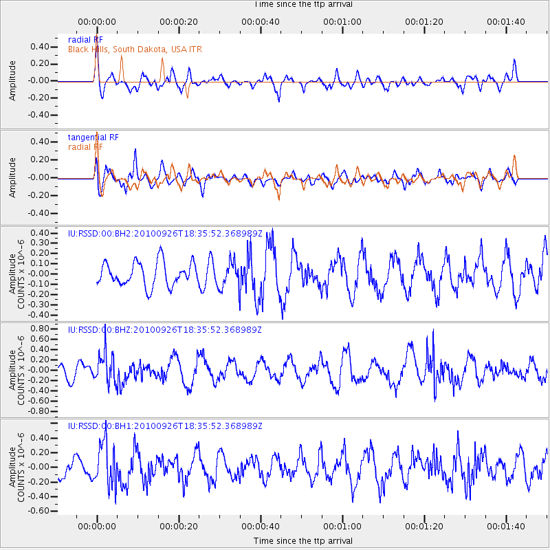
RSSD Black Hills, South Dakota, USA - Earthquake Result Viewer
*The percent match for this event was below the threshold and hence no stack was calculated.
| Earthquake location: |
Rat Islands, Aleutian Islands |
| Earthquake latitude/longitude: |
52.4/179.7 |
| Earthquake time(UTC): |
2010/09/26 (269) 18:27:57 GMT |
| Earthquake Depth: |
226 km |
| Earthquake Magnitude: |
5.8 MW, 5.5 MB, 5.8 MW |
| Earthquake Catalog/Contributor: |
NEIC PDE/NEIC PDE-M |
|
| Network: |
IU Global Seismograph Network (GSN - IRIS/USGS) |
| Station: |
RSSD Black Hills, South Dakota, USA |
| Lat/Lon: |
44.12 N/104.04 W |
| Elevation: |
2090 m |
|
| Distance: |
49.2 deg |
| Az: |
67.539 deg |
| Baz: |
308.229 deg |
| Ray Param: |
$rayparam |
*The percent match for this event was below the threshold and hence was not used in the summary stack. |
|
| Radial Match: |
59.69543 % |
| Radial Bump: |
400 |
| Transverse Match: |
59.067226 % |
| Transverse Bump: |
400 |
| SOD ConfigId: |
617450 |
| Insert Time: |
2013-10-01 11:56:47.081 +0000 |
| GWidth: |
2.5 |
| Max Bumps: |
400 |
| Tol: |
0.001 |
|
Signal To Noise
| Channel | StoN | STA | LTA |
| IU:RSSD:00:BHZ:20100926T18:35:52.368989Z | 2.682917 | 2.970833E-7 | 1.1073144E-7 |
| IU:RSSD:00:BH1:20100926T18:35:52.368989Z | 2.2199802 | 2.9427713E-7 | 1.3255844E-7 |
| IU:RSSD:00:BH2:20100926T18:35:52.368989Z | 1.0809244 | 1.2382418E-7 | 1.1455398E-7 |
| Arrivals |
| Ps | |
| PpPs | |
| PsPs/PpSs | |


