You are here: Home > Network List > IU - Global Seismograph Network (GSN - IRIS/USGS) Stations List
> Station RSSD Black Hills, South Dakota, USA > Earthquake Result Viewer
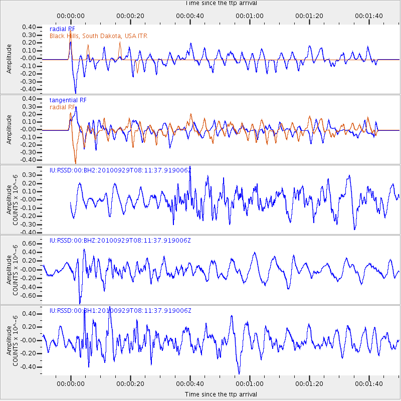
RSSD Black Hills, South Dakota, USA - Earthquake Result Viewer
*The percent match for this event was below the threshold and hence no stack was calculated.
| Earthquake location: |
Eastern Honshu, Japan |
| Earthquake latitude/longitude: |
37.3/139.9 |
| Earthquake time(UTC): |
2010/09/29 (272) 08:00:00 GMT |
| Earthquake Depth: |
33 km |
| Earthquake Magnitude: |
5.5 MW, 5.5 MW, 5.6 MB |
| Earthquake Catalog/Contributor: |
NEIC PDE/NEIC PDE-M |
|
| Network: |
IU Global Seismograph Network (GSN - IRIS/USGS) |
| Station: |
RSSD Black Hills, South Dakota, USA |
| Lat/Lon: |
44.12 N/104.04 W |
| Elevation: |
2090 m |
|
| Distance: |
80.5 deg |
| Az: |
40.989 deg |
| Baz: |
313.392 deg |
| Ray Param: |
$rayparam |
*The percent match for this event was below the threshold and hence was not used in the summary stack. |
|
| Radial Match: |
57.133095 % |
| Radial Bump: |
400 |
| Transverse Match: |
55.49469 % |
| Transverse Bump: |
400 |
| SOD ConfigId: |
617450 |
| Insert Time: |
2013-10-01 12:02:50.803 +0000 |
| GWidth: |
2.5 |
| Max Bumps: |
400 |
| Tol: |
0.001 |
|
Signal To Noise
| Channel | StoN | STA | LTA |
| IU:RSSD:00:BHZ:20100929T08:11:37.919006Z | 3.8432086 | 3.2385051E-7 | 8.4265665E-8 |
| IU:RSSD:00:BH1:20100929T08:11:37.919006Z | 1.5572063 | 1.4629E-7 | 9.394388E-8 |
| IU:RSSD:00:BH2:20100929T08:11:37.919006Z | 0.9562529 | 9.534113E-8 | 9.970284E-8 |
| Arrivals |
| Ps | |
| PpPs | |
| PsPs/PpSs | |


