You are here: Home > Network List > II - Global Seismograph Network (GSN - IRIS/IDA) Stations List
> Station AAK Ala Archa, Kyrgyzstan > Earthquake Result Viewer
AAK Ala Archa, Kyrgyzstan - Earthquake Result Viewer

| Earthquake location: |
Irian Jaya Region, Indonesia |
| Earthquake latitude/longitude: |
-4.9/133.7 |
| Earthquake time(UTC): |
2010/09/29 (272) 17:10:51 GMT |
| Earthquake Depth: |
10 km |
| Earthquake Magnitude: |
7.0 MW, 6.2 MB |
| Earthquake Catalog/Contributor: |
NEIC PDE/NEIC PDE-M |
|
| Network: |
II Global Seismograph Network (GSN - IRIS/IDA) |
| Station: |
AAK Ala Archa, Kyrgyzstan |
| Lat/Lon: |
42.64 N/74.49 E |
| Elevation: |
1645 m |
|
| Distance: |
71.4 deg |
| Az: |
318.02 deg |
| Baz: |
115.423 deg |
| Ray Param: |
0.054351274 |
| Estimated Moho Depth: |
14.5 km |
| Estimated Crust Vp/Vs: |
2.02 |
| Assumed Crust Vp: |
6.306 km/s |
| Estimated Crust Vs: |
3.122 km/s |
| Estimated Crust Poisson's Ratio: |
0.34 |
|
| Radial Match: |
95.89761 % |
| Radial Bump: |
400 |
| Transverse Match: |
92.60419 % |
| Transverse Bump: |
400 |
| SOD ConfigId: |
617450 |
| Insert Time: |
2013-10-01 12:04:19.774 +0000 |
| GWidth: |
2.5 |
| Max Bumps: |
400 |
| Tol: |
0.001 |
|
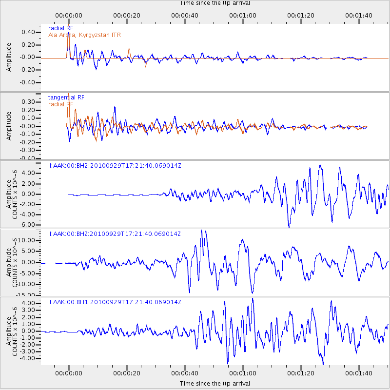
Signal To Noise
| Channel | StoN | STA | LTA |
| II:AAK:00:BHZ:20100929T17:21:40.069014Z | 9.055982 | 4.844321E-7 | 5.349305E-8 |
| II:AAK:00:BH1:20100929T17:21:40.069014Z | 2.425825 | 8.6446136E-8 | 3.5635765E-8 |
| II:AAK:00:BH2:20100929T17:21:40.069014Z | 5.536183 | 1.9307303E-7 | 3.487476E-8 |
| Arrivals |
| Ps | 2.4 SECOND |
| PpPs | 6.7 SECOND |
| PsPs/PpSs | 9.2 SECOND |


