You are here: Home > Network List > II - Global Seismograph Network (GSN - IRIS/IDA) Stations List
> Station KURK Kurchatov, Kazakhstan > Earthquake Result Viewer
KURK Kurchatov, Kazakhstan - Earthquake Result Viewer
| Earthquake location: |
Irian Jaya Region, Indonesia |
| Earthquake latitude/longitude: |
-4.9/133.7 |
| Earthquake time(UTC): |
2010/09/29 (272) 17:10:51 GMT |
| Earthquake Depth: |
10 km |
| Earthquake Magnitude: |
7.0 MW, 6.2 MB |
| Earthquake Catalog/Contributor: |
NEIC PDE/NEIC PDE-M |
|
| Network: |
II Global Seismograph Network (GSN - IRIS/IDA) |
| Station: |
KURK Kurchatov, Kazakhstan |
| Lat/Lon: |
50.72 N/78.62 E |
| Elevation: |
184 m |
|
| Distance: |
72.7 deg |
| Az: |
326.911 deg |
| Baz: |
121.165 deg |
| Ray Param: |
0.05346825 |
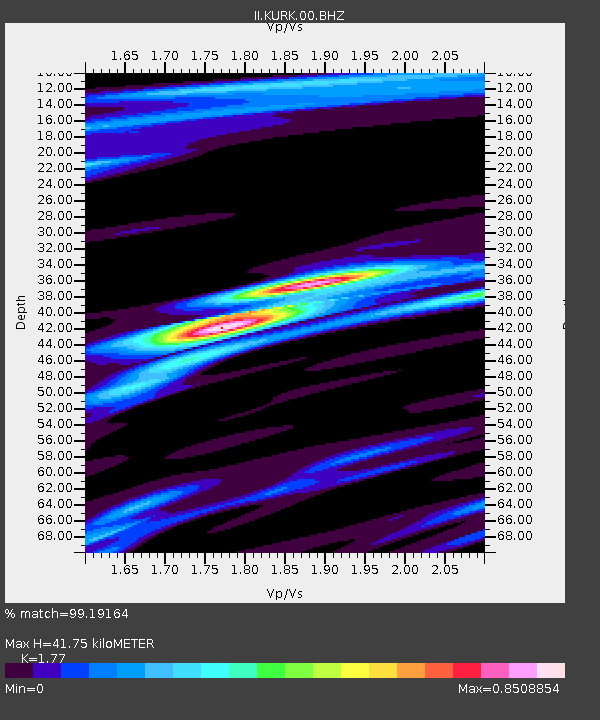
| Estimated Moho Depth: |
41.75 km |
| Estimated Crust Vp/Vs: |
1.77 |
| Assumed Crust Vp: |
6.552 km/s |
| Estimated Crust Vs: |
3.702 km/s |
| Estimated Crust Poisson's Ratio: |
0.27 |
|
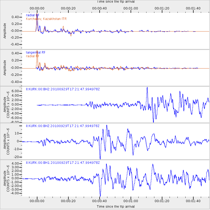
| Radial Match: |
99.19164 % |
| Radial Bump: |
283 |
| Transverse Match: |
96.7919 % |
| Transverse Bump: |
400 |
| SOD ConfigId: |
617450 |
| Insert Time: |
2013-10-01 12:04:21.054 +0000 |
| GWidth: |
2.5 |
| Max Bumps: |
400 |
| Tol: |
0.001 |
|
Signal To Noise
| Channel | StoN | STA | LTA |
| II:KURK:00:BHZ:20100929T17:21:47.994978Z | 36.210896 | 1.7311235E-6 | 4.7806697E-8 |
| II:KURK:00:BH1:20100929T17:21:47.994978Z | 4.6719112 | 2.7207332E-7 | 5.823598E-8 |
| II:KURK:00:BH2:20100929T17:21:47.994978Z | 7.6078367 | 5.0903225E-7 | 6.690894E-8 |
| Arrivals |
| Ps | 5.1 SECOND |
| PpPs | 17 SECOND |
| PsPs/PpSs | 22 SECOND |


