You are here: Home > Network List > II - Global Seismograph Network (GSN - IRIS/IDA) Stations List
> Station PALK Pallekele, Sri Lanka > Earthquake Result Viewer
PALK Pallekele, Sri Lanka - Earthquake Result Viewer
| Earthquake location: |
Irian Jaya Region, Indonesia |
| Earthquake latitude/longitude: |
-4.9/133.7 |
| Earthquake time(UTC): |
2010/09/29 (272) 17:10:51 GMT |
| Earthquake Depth: |
10 km |
| Earthquake Magnitude: |
7.0 MW, 6.2 MB |
| Earthquake Catalog/Contributor: |
NEIC PDE/NEIC PDE-M |
|
| Network: |
II Global Seismograph Network (GSN - IRIS/IDA) |
| Station: |
PALK Pallekele, Sri Lanka |
| Lat/Lon: |
7.27 N/80.70 E |
| Elevation: |
460 m |
|
| Distance: |
54.3 deg |
| Az: |
282.526 deg |
| Baz: |
101.348 deg |
| Ray Param: |
0.06555656 |
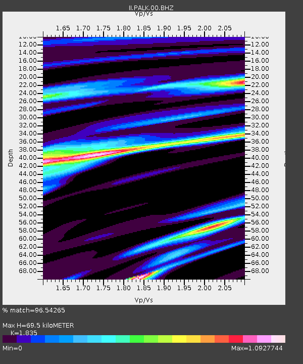
| Estimated Moho Depth: |
69.5 km |
| Estimated Crust Vp/Vs: |
1.84 |
| Assumed Crust Vp: |
6.545 km/s |
| Estimated Crust Vs: |
3.567 km/s |
| Estimated Crust Poisson's Ratio: |
0.29 |
|
| Radial Match: |
96.54265 % |
| Radial Bump: |
400 |
| Transverse Match: |
86.02626 % |
| Transverse Bump: |
400 |
| SOD ConfigId: |
617450 |
| Insert Time: |
2013-10-01 12:04:26.408 +0000 |
| GWidth: |
2.5 |
| Max Bumps: |
400 |
| Tol: |
0.001 |
|
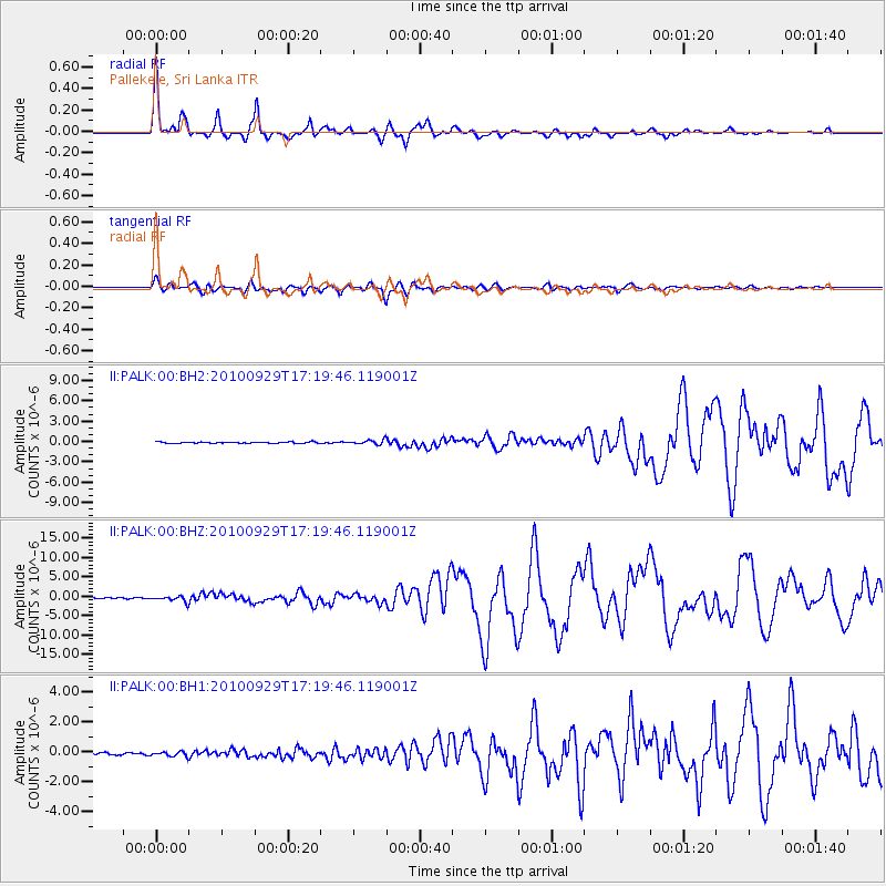
Signal To Noise
| Channel | StoN | STA | LTA |
| II:PALK:00:BHZ:20100929T17:19:46.119001Z | 3.9195828 | 7.147683E-7 | 1.8235826E-7 |
| II:PALK:00:BH1:20100929T17:19:46.119001Z | 1.457122 | 1.4799188E-7 | 1.0156451E-7 |
| II:PALK:00:BH2:20100929T17:19:46.119001Z | 3.278704 | 3.377297E-7 | 1.0300707E-7 |
| Arrivals |
| Ps | 9.4 SECOND |
| PpPs | 29 SECOND |
| PsPs/PpSs | 38 SECOND |


