You are here: Home > Network List > IU - Global Seismograph Network (GSN - IRIS/USGS) Stations List
> Station MAKZ Makanchi, Kazakhstan > Earthquake Result Viewer
MAKZ Makanchi, Kazakhstan - Earthquake Result Viewer
| Earthquake location: |
Irian Jaya Region, Indonesia |
| Earthquake latitude/longitude: |
-4.9/133.7 |
| Earthquake time(UTC): |
2010/09/29 (272) 17:10:51 GMT |
| Earthquake Depth: |
10 km |
| Earthquake Magnitude: |
7.0 MW, 6.2 MB |
| Earthquake Catalog/Contributor: |
NEIC PDE/NEIC PDE-M |
|
| Network: |
IU Global Seismograph Network (GSN - IRIS/USGS) |
| Station: |
MAKZ Makanchi, Kazakhstan |
| Lat/Lon: |
46.81 N/81.98 E |
| Elevation: |
600 m |
|
| Distance: |
68.8 deg |
| Az: |
324.65 deg |
| Baz: |
122.938 deg |
| Ray Param: |
0.056084897 |
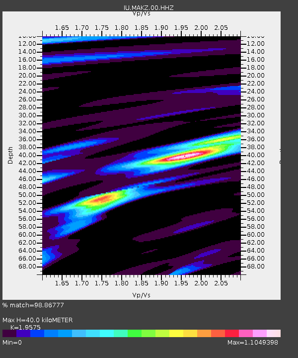
| Estimated Moho Depth: |
40.0 km |
| Estimated Crust Vp/Vs: |
1.96 |
| Assumed Crust Vp: |
6.571 km/s |
| Estimated Crust Vs: |
3.357 km/s |
| Estimated Crust Poisson's Ratio: |
0.32 |
|
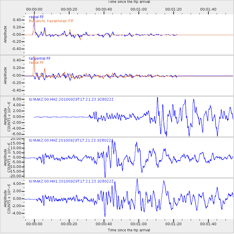
| Radial Match: |
98.86777 % |
| Radial Bump: |
227 |
| Transverse Match: |
94.25901 % |
| Transverse Bump: |
400 |
| SOD ConfigId: |
617450 |
| Insert Time: |
2013-10-01 12:04:42.164 +0000 |
| GWidth: |
2.5 |
| Max Bumps: |
400 |
| Tol: |
0.001 |
|
Signal To Noise
| Channel | StoN | STA | LTA |
| IU:MAKZ:00:HHZ:20100929T17:21:23.928022Z | 33.284794 | 1.5079563E-6 | 4.530466E-8 |
| IU:MAKZ:00:HH1:20100929T17:21:23.928022Z | 5.3169117 | 2.9706766E-7 | 5.5872217E-8 |
| IU:MAKZ:00:HH2:20100929T17:21:23.928022Z | 9.551435 | 4.9127704E-7 | 5.143489E-8 |
| Arrivals |
| Ps | 6.0 SECOND |
| PpPs | 17 SECOND |
| PsPs/PpSs | 23 SECOND |


