You are here: Home > Network List > IU - Global Seismograph Network (GSN - IRIS/USGS) Stations List
> Station JOHN Johnston Island, USA > Earthquake Result Viewer
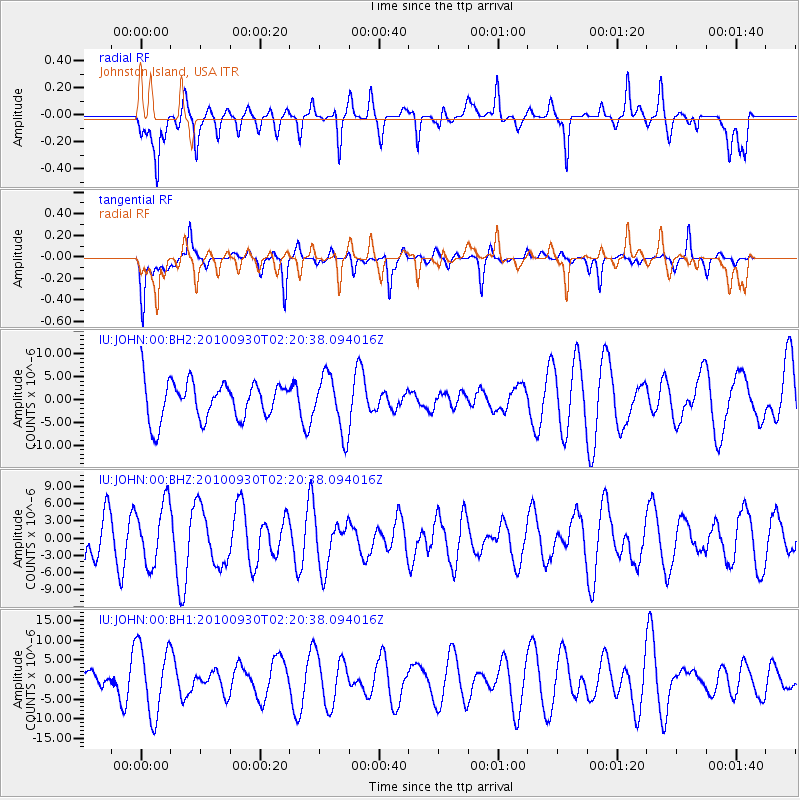
JOHN Johnston Island, USA - Earthquake Result Viewer
*The percent match for this event was below the threshold and hence no stack was calculated.
| Earthquake location: |
Irian Jaya Region, Indonesia |
| Earthquake latitude/longitude: |
-4.9/133.8 |
| Earthquake time(UTC): |
2010/09/30 (273) 02:11:03 GMT |
| Earthquake Depth: |
16 km |
| Earthquake Magnitude: |
5.5 MW, 5.6 MB |
| Earthquake Catalog/Contributor: |
NEIC PDE/NEIC PDE-M |
|
| Network: |
IU Global Seismograph Network (GSN - IRIS/USGS) |
| Station: |
JOHN Johnston Island, USA |
| Lat/Lon: |
16.73 N/169.53 W |
| Elevation: |
2.0 m |
|
| Distance: |
60.0 deg |
| Az: |
67.572 deg |
| Baz: |
253.977 deg |
| Ray Param: |
$rayparam |
*The percent match for this event was below the threshold and hence was not used in the summary stack. |
|
| Radial Match: |
51.36116 % |
| Radial Bump: |
400 |
| Transverse Match: |
54.826347 % |
| Transverse Bump: |
295 |
| SOD ConfigId: |
617450 |
| Insert Time: |
2013-10-01 12:09:53.339 +0000 |
| GWidth: |
2.5 |
| Max Bumps: |
400 |
| Tol: |
0.001 |
|
Signal To Noise
| Channel | StoN | STA | LTA |
| IU:JOHN:00:BHZ:20100930T02:20:38.094016Z | 1.1363043 | 5.298191E-6 | 4.6626515E-6 |
| IU:JOHN:00:BH1:20100930T02:20:38.094016Z | 1.9194765 | 8.810614E-6 | 4.5901133E-6 |
| IU:JOHN:00:BH2:20100930T02:20:38.094016Z | 1.503828 | 6.187187E-6 | 4.1142916E-6 |
| Arrivals |
| Ps | |
| PpPs | |
| PsPs/PpSs | |


