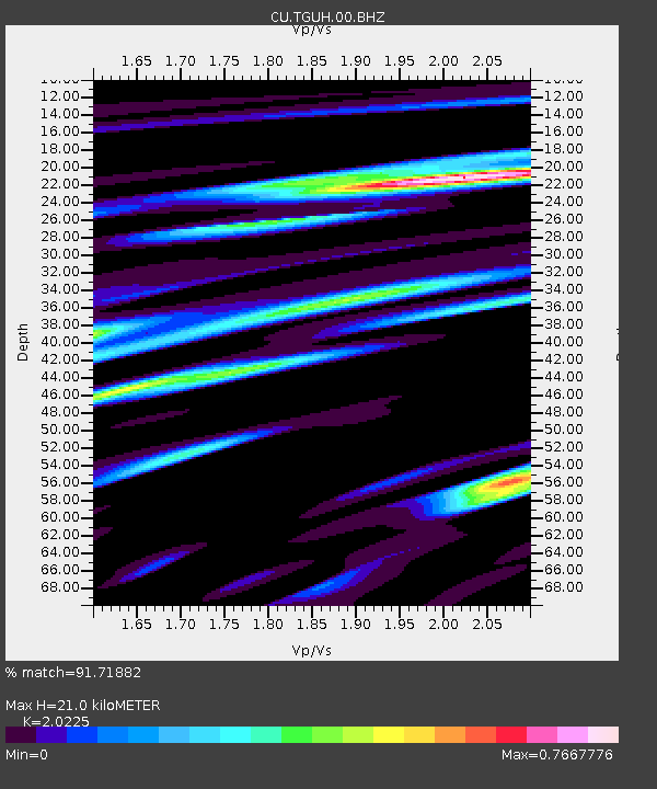
TGUH Tegucigalpa, Honduras - Earthquake Result Viewer

Earthquake location: Andreanof Islands, Aleutian Is.
Earthquake latitude/longitude: 51.4/-175.4
Earthquake time(UTC): 2010/10/08 (281) 03:26:13 GMT
Earthquake Depth: 19 km
Earthquake Magnitude: 6.2 MB, 6.3 MS, 6.4 MW, 6.2 MW
Earthquake Catalog/Contributor: WHDF/NEIC
Network: CU Caribbean Network (USGS)
Station: TGUH Tegucigalpa, Honduras
Lat/Lon: 14.06 N/87.27 W
Elevation: 0.0 m
Distance: 78.0 deg
Az: 82.595 deg
Baz: 320.171 deg
Ray Param: 0.04994082
Estimated Moho Depth: 21.0 km
Estimated Crust Vp/Vs: 2.02
Assumed Crust Vp: 6.597 km/s
Estimated Crust Vs: 3.262 km/s
Estimated Crust Poisson's Ratio: 0.34
Radial Match: 91.71882 %
Radial Bump: 400
Transverse Match: 83.34676 %
Transverse Bump: 400
SOD ConfigId: 617450
Insert Time: 2013-10-01 12:33:00.472 +0000
GWidth: 2.5
Max Bumps: 400
Tol: 0.001

Signal To Noise

ChannelStoNSTALTA
CU:TGUH:00:BHZ:20101008T03:37:39.275002Z11.232431.8483374E-61.6455364E-7
CU:TGUH:00:BH1:20101008T03:37:39.275002Z1.27143623.0289382E-72.3822967E-7
CU:TGUH:00:BH2:20101008T03:37:39.275002Z4.54043539.006575E-71.9836368E-7
Arrivals
Ps3.3 SECOND
PpPs9.4 SECOND
PsPs/PpSs13 SECOND