KAPI Kappang, Sulawesi, Indonesia - Earthquake Result Viewer
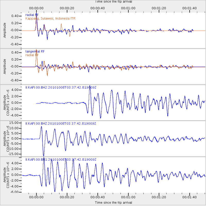
Earthquake location: Andreanof Islands, Aleutian Is.
Earthquake latitude/longitude: 51.4/-175.4
Earthquake time(UTC): 2010/10/08 (281) 03:26:13 GMT
Earthquake Depth: 19 km
Earthquake Magnitude: 6.2 MB, 6.3 MS, 6.4 MW, 6.2 MW
Earthquake Catalog/Contributor: WHDF/NEIC
Network: II Global Seismograph Network (GSN - IRIS/IDA)
Station: KAPI Kappang, Sulawesi, Indonesia
Lat/Lon: 5.01 S/119.75 E
Elevation: 300 m
Distance: 78.6 deg
Az: 246.948 deg
Baz: 35.375 deg
Ray Param: 0.04950274
Estimated Moho Depth: 33.0 km
Estimated Crust Vp/Vs: 1.94
Assumed Crust Vp: 6.343 km/s
Estimated Crust Vs: 3.266 km/s
Estimated Crust Poisson's Ratio: 0.32
Radial Match: 98.428116 %
Radial Bump: 368
Transverse Match: 90.733505 %
Transverse Bump: 400
SOD ConfigId: 617450
Insert Time: 2013-10-01 12:33:09.473 +0000
GWidth: 2.5
Max Bumps: 400
Tol: 0.001

Signal To Noise

ChannelStoNSTALTA
II:KAPI:00:BHZ:20101008T03:37:42.819009Z53.9415056.6968228E-61.2414972E-7
II:KAPI:00:BH1:20101008T03:37:42.819009Z21.6495462.0454486E-69.447998E-8
II:KAPI:00:BH2:20101008T03:37:42.819009Z17.5269091.7309735E-69.8760914E-8
Arrivals
Ps5.0 SECOND
PpPs15 SECOND
PsPs/PpSs20 SECOND