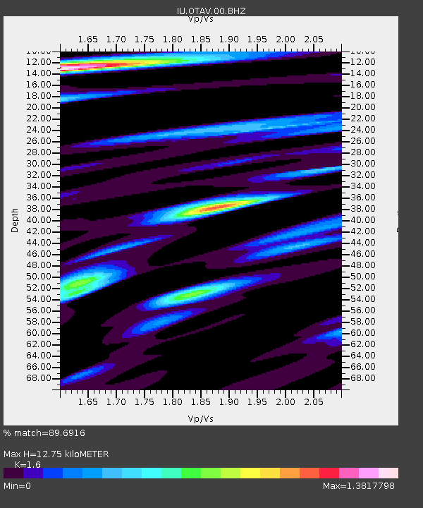
OTAV Otavalo, Ecuador - Earthquake Result Viewer

Earthquake location: Andreanof Islands, Aleutian Is.
Earthquake latitude/longitude: 51.4/-175.4
Earthquake time(UTC): 2010/10/08 (281) 03:26:13 GMT
Earthquake Depth: 19 km
Earthquake Magnitude: 6.2 MB, 6.3 MS, 6.4 MW, 6.2 MW
Earthquake Catalog/Contributor: WHDF/NEIC
Network: IU Global Seismograph Network (GSN - IRIS/USGS)
Station: OTAV Otavalo, Ecuador
Lat/Lon: 0.24 N/78.45 W
Elevation: 3510 m
Distance: 94.1 deg
Az: 84.458 deg
Baz: 321.401 deg
Ray Param: 0.041108493
Estimated Moho Depth: 12.75 km
Estimated Crust Vp/Vs: 1.60
Assumed Crust Vp: 6.472 km/s
Estimated Crust Vs: 4.045 km/s
Estimated Crust Poisson's Ratio: 0.18
Radial Match: 89.6916 %
Radial Bump: 400
Transverse Match: 74.78002 %
Transverse Bump: 400
SOD ConfigId: 617450
Insert Time: 2013-10-01 12:33:44.763 +0000
GWidth: 2.5
Max Bumps: 400
Tol: 0.001

Signal To Noise

ChannelStoNSTALTA
IU:OTAV:00:BHZ:20101008T03:38:59.418984Z8.8147325.036276E-75.7134756E-8
IU:OTAV:00:BH1:20101008T03:38:59.418984Z3.29980781.813887E-75.4969476E-8
IU:OTAV:00:BH2:20101008T03:38:59.418984Z2.01768162.640591E-71.3087254E-7
Arrivals
Ps1.2 SECOND
PpPs5.0 SECOND
PsPs/PpSs6.2 SECOND