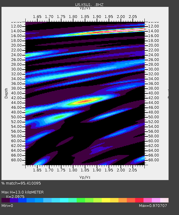
KSU1 Kansas State University--Konza Prairie, Kansas, USA - Earthquake Result Viewer

Earthquake location: Andreanof Islands, Aleutian Is.
Earthquake latitude/longitude: 51.4/-175.4
Earthquake time(UTC): 2010/10/08 (281) 03:26:13 GMT
Earthquake Depth: 19 km
Earthquake Magnitude: 6.2 MB, 6.3 MS, 6.4 MW, 6.2 MW
Earthquake Catalog/Contributor: WHDF/NEIC
Network: US United States National Seismic Network
Station: KSU1 Kansas State University--Konza Prairie, Kansas, USA
Lat/Lon: 39.10 N/96.61 W
Elevation: 347 m
Distance: 54.2 deg
Az: 70.154 deg
Baz: 310.739 deg
Ray Param: 0.0655585
Estimated Moho Depth: 13.0 km
Estimated Crust Vp/Vs: 2.10
Assumed Crust Vp: 6.483 km/s
Estimated Crust Vs: 3.091 km/s
Estimated Crust Poisson's Ratio: 0.35
Radial Match: 95.410095 %
Radial Bump: 400
Transverse Match: 73.897865 %
Transverse Bump: 400
SOD ConfigId: 617450
Insert Time: 2013-10-01 12:34:10.829 +0000
GWidth: 2.5
Max Bumps: 400
Tol: 0.001

Signal To Noise

ChannelStoNSTALTA
US:KSU1: :BHZ:20101008T03:35:07.149026Z9.7221362.110306E-62.1706198E-7
US:KSU1: :BH1:20101008T03:35:07.149026Z1.74303174.579598E-72.627375E-7
US:KSU1: :BH2:20101008T03:35:07.149026Z4.38940051.1145403E-62.5391628E-7
Arrivals
Ps2.3 SECOND
PpPs5.9 SECOND
PsPs/PpSs8.2 SECOND