You are here: Home > Network List > II - Global Seismograph Network (GSN - IRIS/IDA) Stations List
> Station KAPI Kappang, Sulawesi, Indonesia > Earthquake Result Viewer
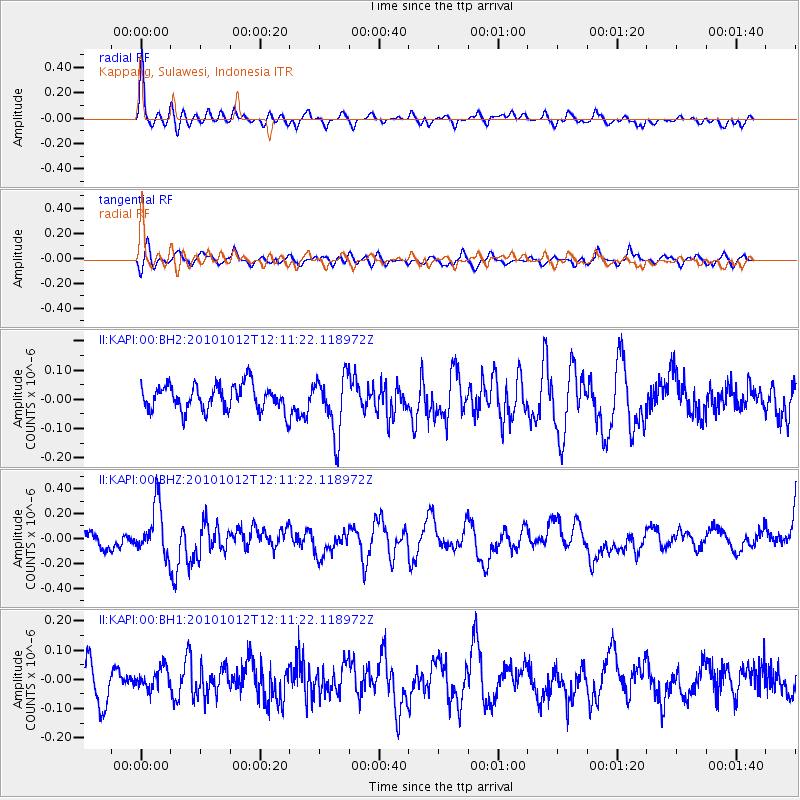
KAPI Kappang, Sulawesi, Indonesia - Earthquake Result Viewer
*The percent match for this event was below the threshold and hence no stack was calculated.
| Earthquake location: |
Tonga Islands |
| Earthquake latitude/longitude: |
-20.5/-174.2 |
| Earthquake time(UTC): |
2010/10/12 (285) 12:01:07 GMT |
| Earthquake Depth: |
10 km |
| Earthquake Magnitude: |
5.9 MB, 5.8 MS |
| Earthquake Catalog/Contributor: |
WHDF/NEIC |
|
| Network: |
II Global Seismograph Network (GSN - IRIS/IDA) |
| Station: |
KAPI Kappang, Sulawesi, Indonesia |
| Lat/Lon: |
5.01 S/119.75 E |
| Elevation: |
300 m |
|
| Distance: |
65.8 deg |
| Az: |
273.716 deg |
| Baz: |
110.07 deg |
| Ray Param: |
$rayparam |
*The percent match for this event was below the threshold and hence was not used in the summary stack. |
|
| Radial Match: |
73.14431 % |
| Radial Bump: |
400 |
| Transverse Match: |
53.87022 % |
| Transverse Bump: |
400 |
| SOD ConfigId: |
617450 |
| Insert Time: |
2013-10-01 12:46:47.987 +0000 |
| GWidth: |
2.5 |
| Max Bumps: |
400 |
| Tol: |
0.001 |
|
Signal To Noise
| Channel | StoN | STA | LTA |
| II:KAPI:00:BHZ:20101012T12:11:22.118972Z | 3.1122284 | 2.030463E-7 | 6.524145E-8 |
| II:KAPI:00:BH1:20101012T12:11:22.118972Z | 0.6870757 | 3.6492857E-8 | 5.31133E-8 |
| II:KAPI:00:BH2:20101012T12:11:22.118972Z | 2.2856638 | 1.003008E-7 | 4.388257E-8 |
| Arrivals |
| Ps | |
| PpPs | |
| PsPs/PpSs | |


