You are here: Home > Network List > IU - Global Seismograph Network (GSN - IRIS/USGS) Stations List
> Station HNR Honiara, Solomon Islands > Earthquake Result Viewer
HNR Honiara, Solomon Islands - Earthquake Result Viewer
| Earthquake location: |
Banda Sea |
| Earthquake latitude/longitude: |
-7.4/125.7 |
| Earthquake time(UTC): |
2010/10/16 (289) 15:44:30 GMT |
| Earthquake Depth: |
8.0 km |
| Earthquake Magnitude: |
6.2 MB, 5.4 MS, 5.9 MW, 5.9 MW |
| Earthquake Catalog/Contributor: |
WHDF/NEIC |
|
| Network: |
IU Global Seismograph Network (GSN - IRIS/USGS) |
| Station: |
HNR Honiara, Solomon Islands |
| Lat/Lon: |
9.44 S/159.95 E |
| Elevation: |
100 m |
|
| Distance: |
33.9 deg |
| Az: |
95.934 deg |
| Baz: |
270.81 deg |
| Ray Param: |
0.07798238 |
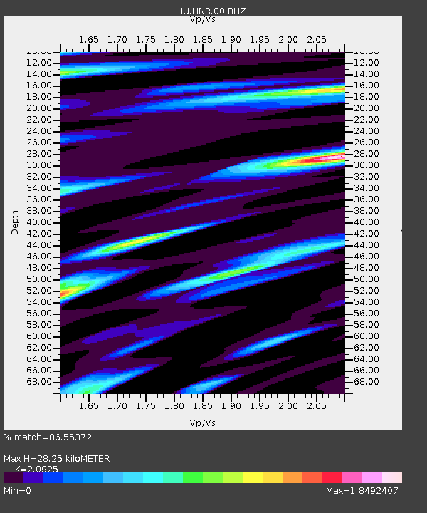
| Estimated Moho Depth: |
28.25 km |
| Estimated Crust Vp/Vs: |
2.09 |
| Assumed Crust Vp: |
6.183 km/s |
| Estimated Crust Vs: |
2.955 km/s |
| Estimated Crust Poisson's Ratio: |
0.35 |
|
| Radial Match: |
86.55372 % |
| Radial Bump: |
400 |
| Transverse Match: |
75.418915 % |
| Transverse Bump: |
400 |
| SOD ConfigId: |
617450 |
| Insert Time: |
2013-10-01 12:54:29.840 +0000 |
| GWidth: |
2.5 |
| Max Bumps: |
400 |
| Tol: |
0.001 |
|
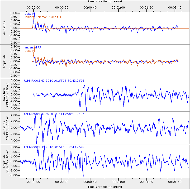
Signal To Noise
| Channel | StoN | STA | LTA |
| IU:HNR:00:BHZ:20101016T15:50:43.269Z | 7.5458393 | 2.444252E-6 | 3.2392052E-7 |
| IU:HNR:00:BH1:20101016T15:50:43.269Z | 4.467402 | 1.368106E-6 | 3.06242E-7 |
| IU:HNR:00:BH2:20101016T15:50:43.269Z | 6.179903 | 1.4748896E-6 | 2.3865903E-7 |
| Arrivals |
| Ps | 5.3 SECOND |
| PpPs | 13 SECOND |
| PsPs/PpSs | 19 SECOND |


