You are here: Home > Network List > IU - Global Seismograph Network (GSN - IRIS/USGS) Stations List
> Station RSSD Black Hills, South Dakota, USA > Earthquake Result Viewer
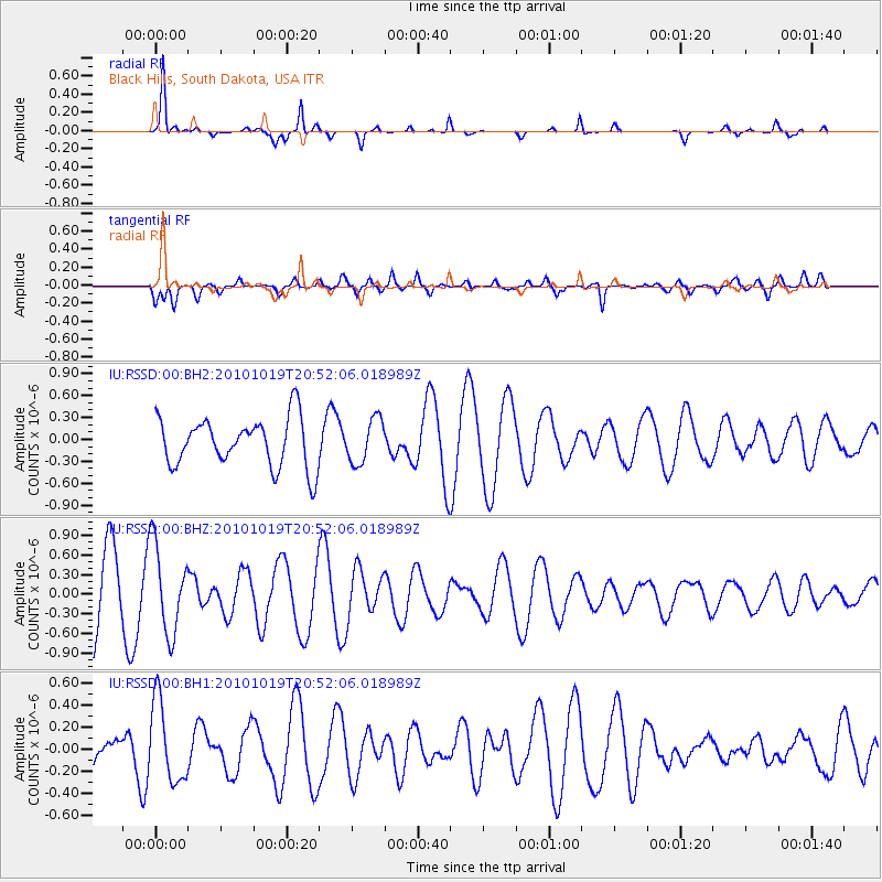
RSSD Black Hills, South Dakota, USA - Earthquake Result Viewer
*The percent match for this event was below the threshold and hence no stack was calculated.
| Earthquake location: |
Tonga Islands |
| Earthquake latitude/longitude: |
-20.3/-173.8 |
| Earthquake time(UTC): |
2010/10/19 (292) 20:39:36 GMT |
| Earthquake Depth: |
10 km |
| Earthquake Magnitude: |
5.6 MB, 5.1 MS, 5.2 MW |
| Earthquake Catalog/Contributor: |
WHDF/NEIC |
|
| Network: |
IU Global Seismograph Network (GSN - IRIS/USGS) |
| Station: |
RSSD Black Hills, South Dakota, USA |
| Lat/Lon: |
44.12 N/104.04 W |
| Elevation: |
2090 m |
|
| Distance: |
90.3 deg |
| Az: |
42.504 deg |
| Baz: |
241.678 deg |
| Ray Param: |
$rayparam |
*The percent match for this event was below the threshold and hence was not used in the summary stack. |
|
| Radial Match: |
81.96543 % |
| Radial Bump: |
221 |
| Transverse Match: |
51.427757 % |
| Transverse Bump: |
400 |
| SOD ConfigId: |
617450 |
| Insert Time: |
2013-10-01 13:00:55.714 +0000 |
| GWidth: |
2.5 |
| Max Bumps: |
400 |
| Tol: |
0.001 |
|
Signal To Noise
| Channel | StoN | STA | LTA |
| IU:RSSD:00:BHZ:20101019T20:52:06.018989Z | 1.4692951 | 6.678217E-7 | 4.5451844E-7 |
| IU:RSSD:00:BH1:20101019T20:52:06.018989Z | 2.2218437 | 3.6618337E-7 | 1.6481059E-7 |
| IU:RSSD:00:BH2:20101019T20:52:06.018989Z | 0.90575004 | 3.034597E-7 | 3.350369E-7 |
| Arrivals |
| Ps | |
| PpPs | |
| PsPs/PpSs | |


