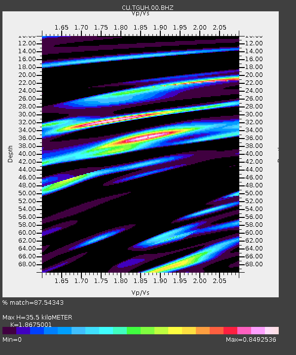
TGUH Tegucigalpa, Honduras - Earthquake Result Viewer

Earthquake location: Off Coast Of Central Chile
Earthquake latitude/longitude: -34.7/-73.7
Earthquake time(UTC): 2010/10/21 (294) 02:49:56 GMT
Earthquake Depth: 10 km
Earthquake Magnitude: 5.9 MB, 5.5 MS, 5.9 MW, 5.8 MW
Earthquake Catalog/Contributor: WHDF/NEIC
Network: CU Caribbean Network (USGS)
Station: TGUH Tegucigalpa, Honduras
Lat/Lon: 14.06 N/87.27 W
Elevation: 0.0 m
Distance: 50.2 deg
Az: 342.784 deg
Baz: 165.453 deg
Ray Param: 0.06821222
Estimated Moho Depth: 35.5 km
Estimated Crust Vp/Vs: 1.87
Assumed Crust Vp: 6.597 km/s
Estimated Crust Vs: 3.533 km/s
Estimated Crust Poisson's Ratio: 0.30
Radial Match: 87.54343 %
Radial Bump: 400
Transverse Match: 73.295944 %
Transverse Bump: 400
SOD ConfigId: 617450
Insert Time: 2013-10-01 13:08:22.807 +0000
GWidth: 2.5
Max Bumps: 400
Tol: 0.001

Signal To Noise

ChannelStoNSTALTA
CU:TGUH:00:BHZ:20101021T02:58:20.80001Z4.9642916.416021E-71.2924345E-7
CU:TGUH:00:BH1:20101021T02:58:20.80001Z2.63393713.60977E-71.3704845E-7
CU:TGUH:00:BH2:20101021T02:58:20.80001Z1.05402741.4771514E-71.4014354E-7
Arrivals
Ps4.9 SECOND
PpPs15 SECOND
PsPs/PpSs20 SECOND