You are here: Home > Network List > CU - Caribbean Network (USGS) Stations List
> Station SDDR Presa de Sabaneta, Dominican Republic > Earthquake Result Viewer
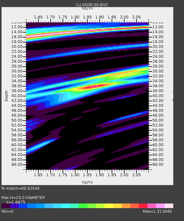
SDDR Presa de Sabaneta, Dominican Republic - Earthquake Result Viewer
| Earthquake location: |
Gulf Of California |
| Earthquake latitude/longitude: |
24.7/-109.2 |
| Earthquake time(UTC): |
2010/10/21 (294) 17:53:13 GMT |
| Earthquake Depth: |
10 km |
| Earthquake Magnitude: |
6.2 MB, 6.8 MS, 6.7 MW, 6.7 MW |
| Earthquake Catalog/Contributor: |
WHDF/NEIC |
|
| Network: |
CU Caribbean Network (USGS) |
| Station: |
SDDR Presa de Sabaneta, Dominican Republic |
| Lat/Lon: |
18.98 N/71.29 W |
| Elevation: |
589 m |
|
| Distance: |
35.5 deg |
| Az: |
91.596 deg |
| Baz: |
286.075 deg |
| Ray Param: |
0.077173494 |
| Estimated Moho Depth: |
15.0 km |
| Estimated Crust Vp/Vs: |
1.67 |
| Assumed Crust Vp: |
6.448 km/s |
| Estimated Crust Vs: |
3.867 km/s |
| Estimated Crust Poisson's Ratio: |
0.22 |
|
| Radial Match: |
86.52548 % |
| Radial Bump: |
201 |
| Transverse Match: |
75.83363 % |
| Transverse Bump: |
400 |
| SOD ConfigId: |
617450 |
| Insert Time: |
2013-10-01 13:11:59.491 +0000 |
| GWidth: |
2.5 |
| Max Bumps: |
400 |
| Tol: |
0.001 |
|

Signal To Noise
| Channel | StoN | STA | LTA |
| CU:SDDR:00:BHZ:20101021T17:59:39.35001Z | 25.60023 | 3.0945146E-6 | 1.208784E-7 |
| CU:SDDR:00:BH1:20101021T17:59:39.35001Z | 5.0681915 | 7.1794534E-7 | 1.416571E-7 |
| CU:SDDR:00:BH2:20101021T17:59:39.35001Z | 15.349939 | 1.7186078E-6 | 1.1196186E-7 |
| Arrivals |
| Ps | 1.7 SECOND |
| PpPs | 5.7 SECOND |
| PsPs/PpSs | 7.4 SECOND |


