You are here: Home > Network List > IU - Global Seismograph Network (GSN - IRIS/USGS) Stations List
> Station TEIG Tepich, Yucatan, Mexico > Earthquake Result Viewer
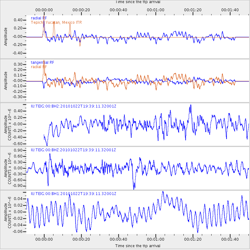
TEIG Tepich, Yucatan, Mexico - Earthquake Result Viewer
*The percent match for this event was below the threshold and hence no stack was calculated.
| Earthquake location: |
Chile-Bolivia Border Region |
| Earthquake latitude/longitude: |
-20.9/-68.4 |
| Earthquake time(UTC): |
2010/10/22 (295) 19:31:37 GMT |
| Earthquake Depth: |
132 km |
| Earthquake Magnitude: |
5.8 MW, 5.4 MB, 5.8 MW |
| Earthquake Catalog/Contributor: |
WHDF/NEIC |
|
| Network: |
IU Global Seismograph Network (GSN - IRIS/USGS) |
| Station: |
TEIG Tepich, Yucatan, Mexico |
| Lat/Lon: |
20.23 N/88.28 W |
| Elevation: |
40 m |
|
| Distance: |
45.3 deg |
| Az: |
333.248 deg |
| Baz: |
153.369 deg |
| Ray Param: |
$rayparam |
*The percent match for this event was below the threshold and hence was not used in the summary stack. |
|
| Radial Match: |
49.479717 % |
| Radial Bump: |
400 |
| Transverse Match: |
48.10265 % |
| Transverse Bump: |
400 |
| SOD ConfigId: |
617450 |
| Insert Time: |
2013-10-01 13:13:59.513 +0000 |
| GWidth: |
2.5 |
| Max Bumps: |
400 |
| Tol: |
0.001 |
|
Signal To Noise
| Channel | StoN | STA | LTA |
| IU:TEIG:00:BHZ:20101022T19:39:11.32001Z | 2.2449937 | 3.832523E-7 | 1.7071422E-7 |
| IU:TEIG:00:BH1:20101022T19:39:11.32001Z | 1.1477408 | 2.8695151E-8 | 2.500142E-8 |
| IU:TEIG:00:BH2:20101022T19:39:11.32001Z | 0.77392286 | 1.5095542E-7 | 1.950523E-7 |
| Arrivals |
| Ps | |
| PpPs | |
| PsPs/PpSs | |


