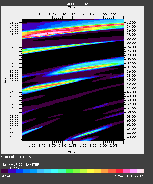
ABPO Ambohimpanompo, Madagascar - Earthquake Result Viewer

Earthquake location: Southern Sumatra, Indonesia
Earthquake latitude/longitude: -3.0/100.4
Earthquake time(UTC): 2010/10/25 (298) 19:37:31 GMT
Earthquake Depth: 26 km
Earthquake Magnitude: 6.0 MB, 6.1 MS, 6.3 MW, 6.3 ME
Earthquake Catalog/Contributor: WHDF/NEIC
Network: II Global Seismograph Network (GSN - IRIS/IDA)
Station: ABPO Ambohimpanompo, Madagascar
Lat/Lon: 19.02 S/47.23 E
Elevation: 1528 m
Distance: 54.3 deg
Az: 248.749 deg
Baz: 79.678 deg
Ray Param: 0.065486066
Estimated Moho Depth: 17.25 km
Estimated Crust Vp/Vs: 1.73
Assumed Crust Vp: 6.642 km/s
Estimated Crust Vs: 3.85 km/s
Estimated Crust Poisson's Ratio: 0.25
Radial Match: 81.17151 %
Radial Bump: 388
Transverse Match: 55.86311 %
Transverse Bump: 400
SOD ConfigId: 617450
Insert Time: 2013-10-01 13:26:03.111 +0000
GWidth: 2.5
Max Bumps: 400
Tol: 0.001

Signal To Noise

ChannelStoNSTALTA
II:ABPO:00:BHZ:20101025T19:46:24.368994Z3.1960095.485707E-71.7164243E-7
II:ABPO:00:BH1:20101025T19:46:24.368994Z1.18956841.3862848E-71.1653679E-7
II:ABPO:00:BH2:20101025T19:46:24.368994Z3.7724644.0252968E-71.0670206E-7
Arrivals
Ps2.0 SECOND
PpPs6.7 SECOND
PsPs/PpSs8.7 SECOND