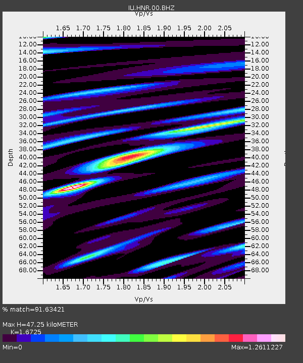
HNR Honiara, Solomon Islands - Earthquake Result Viewer
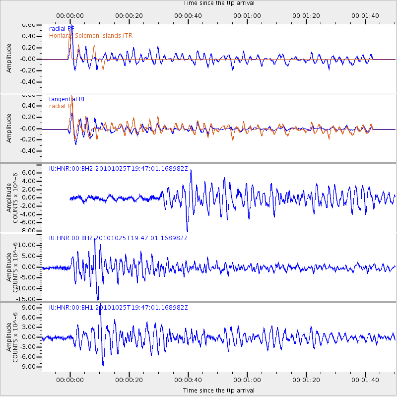
Earthquake location: Southern Sumatra, Indonesia
Earthquake latitude/longitude: -3.0/100.4
Earthquake time(UTC): 2010/10/25 (298) 19:37:31 GMT
Earthquake Depth: 26 km
Earthquake Magnitude: 6.0 MB, 6.1 MS, 6.3 MW, 6.3 ME
Earthquake Catalog/Contributor: WHDF/NEIC
Network: IU Global Seismograph Network (GSN - IRIS/USGS)
Station: HNR Honiara, Solomon Islands
Lat/Lon: 9.44 S/159.95 E
Elevation: 100 m
Distance: 59.5 deg
Az: 99.154 deg
Baz: 272.116 deg
Ray Param: 0.062099304
Estimated Moho Depth: 47.25 km
Estimated Crust Vp/Vs: 1.67
Assumed Crust Vp: 6.183 km/s
Estimated Crust Vs: 3.697 km/s
Estimated Crust Poisson's Ratio: 0.22
Radial Match: 91.63421 %
Radial Bump: 400
Transverse Match: 93.90697 %
Transverse Bump: 400
SOD ConfigId: 617450
Insert Time: 2013-10-01 13:26:19.743 +0000
GWidth: 2.5
Max Bumps: 400
Tol: 0.001

Signal To Noise

ChannelStoNSTALTA
IU:HNR:00:BHZ:20101025T19:47:01.168982Z9.74941353.704384E-63.799597E-7
IU:HNR:00:BH1:20101025T19:47:01.168982Z5.4184061.7944277E-63.3117263E-7
IU:HNR:00:BH2:20101025T19:47:01.168982Z3.53545571.3986185E-63.9559777E-7
Arrivals
Ps5.4 SECOND
PpPs19 SECOND
PsPs/PpSs25 SECOND