You are here: Home > Network List > IU - Global Seismograph Network (GSN - IRIS/USGS) Stations List
> Station HNR Honiara, Solomon Islands > Earthquake Result Viewer
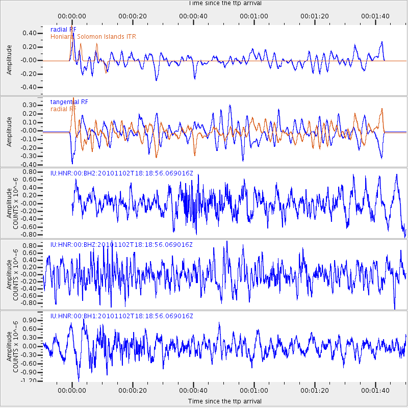
HNR Honiara, Solomon Islands - Earthquake Result Viewer
*The percent match for this event was below the threshold and hence no stack was calculated.
| Earthquake location: |
Northwest Of Kuril Islands |
| Earthquake latitude/longitude: |
47.1/146.7 |
| Earthquake time(UTC): |
2010/11/02 (306) 18:10:14 GMT |
| Earthquake Depth: |
369 km |
| Earthquake Magnitude: |
5.5 MW |
| Earthquake Catalog/Contributor: |
NEIC PDE/NEIC PDE-M |
|
| Network: |
IU Global Seismograph Network (GSN - IRIS/USGS) |
| Station: |
HNR Honiara, Solomon Islands |
| Lat/Lon: |
9.44 S/159.95 E |
| Elevation: |
100 m |
|
| Distance: |
57.5 deg |
| Az: |
164.505 deg |
| Baz: |
349.338 deg |
| Ray Param: |
$rayparam |
*The percent match for this event was below the threshold and hence was not used in the summary stack. |
|
| Radial Match: |
57.311626 % |
| Radial Bump: |
400 |
| Transverse Match: |
64.04351 % |
| Transverse Bump: |
400 |
| SOD ConfigId: |
617450 |
| Insert Time: |
2013-10-01 13:51:14.938 +0000 |
| GWidth: |
2.5 |
| Max Bumps: |
400 |
| Tol: |
0.001 |
|
Signal To Noise
| Channel | StoN | STA | LTA |
| IU:HNR:00:BHZ:20101102T18:18:56.069016Z | 0.9748473 | 3.2286292E-7 | 3.3119332E-7 |
| IU:HNR:00:BH1:20101102T18:18:56.069016Z | 2.3167124 | 6.1687945E-7 | 2.6627364E-7 |
| IU:HNR:00:BH2:20101102T18:18:56.069016Z | 1.6530184 | 3.3325188E-7 | 2.0160205E-7 |
| Arrivals |
| Ps | |
| PpPs | |
| PsPs/PpSs | |


