You are here: Home > Network List > II - Global Seismograph Network (GSN - IRIS/IDA) Stations List
> Station WRAB Tennant Creek, NT, Australia > Earthquake Result Viewer
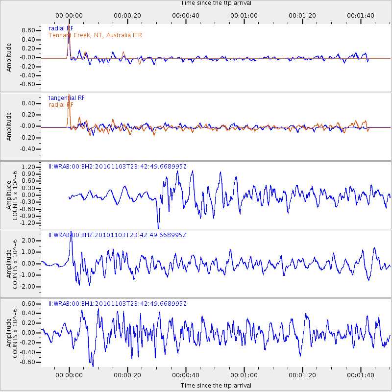
WRAB Tennant Creek, NT, Australia - Earthquake Result Viewer
*The percent match for this event was below the threshold and hence no stack was calculated.
| Earthquake location: |
Tonga Islands |
| Earthquake latitude/longitude: |
-20.5/-174.3 |
| Earthquake time(UTC): |
2010/11/03 (307) 23:34:42 GMT |
| Earthquake Depth: |
18 km |
| Earthquake Magnitude: |
6.1 MW, 5.9 MS, 6.1 MB, 6.1 MW |
| Earthquake Catalog/Contributor: |
NEIC PDE/NEIC PDE-M |
|
| Network: |
II Global Seismograph Network (GSN - IRIS/IDA) |
| Station: |
WRAB Tennant Creek, NT, Australia |
| Lat/Lon: |
19.93 S/134.36 E |
| Elevation: |
366 m |
|
| Distance: |
48.0 deg |
| Az: |
261.214 deg |
| Baz: |
99.959 deg |
| Ray Param: |
$rayparam |
*The percent match for this event was below the threshold and hence was not used in the summary stack. |
|
| Radial Match: |
79.626564 % |
| Radial Bump: |
382 |
| Transverse Match: |
70.04862 % |
| Transverse Bump: |
400 |
| SOD ConfigId: |
617450 |
| Insert Time: |
2013-10-01 13:59:10.885 +0000 |
| GWidth: |
2.5 |
| Max Bumps: |
400 |
| Tol: |
0.001 |
|
Signal To Noise
| Channel | StoN | STA | LTA |
| II:WRAB:00:BHZ:20101103T23:42:49.668995Z | 4.901644 | 1.2147455E-6 | 2.478241E-7 |
| II:WRAB:00:BH1:20101103T23:42:49.668995Z | 1.1462843 | 1.9981226E-7 | 1.74313E-7 |
| II:WRAB:00:BH2:20101103T23:42:49.668995Z | 3.756914 | 5.8580986E-7 | 1.5592848E-7 |
| Arrivals |
| Ps | |
| PpPs | |
| PsPs/PpSs | |


