You are here: Home > Network List > IU - Global Seismograph Network (GSN - IRIS/USGS) Stations List
> Station RSSD Black Hills, South Dakota, USA > Earthquake Result Viewer
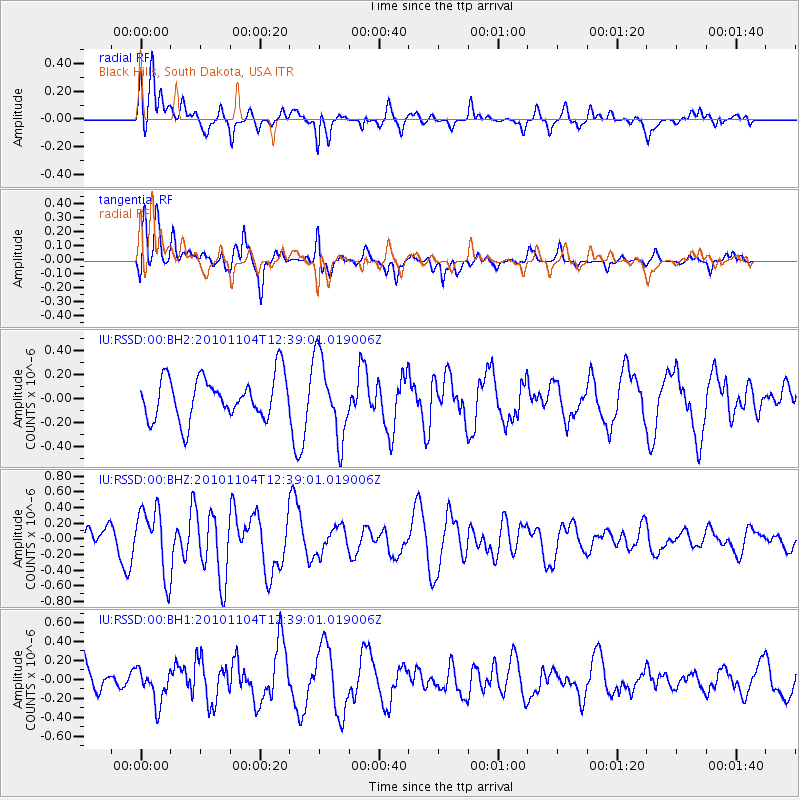
RSSD Black Hills, South Dakota, USA - Earthquake Result Viewer
*The percent match for this event was below the threshold and hence no stack was calculated.
| Earthquake location: |
Northern Mid-Atlantic Ridge |
| Earthquake latitude/longitude: |
12.8/-44.8 |
| Earthquake time(UTC): |
2010/11/04 (308) 12:29:31 GMT |
| Earthquake Depth: |
10 km |
| Earthquake Magnitude: |
5.6 MB |
| Earthquake Catalog/Contributor: |
NEIC PDE/NEIC PDE-M |
|
| Network: |
IU Global Seismograph Network (GSN - IRIS/USGS) |
| Station: |
RSSD Black Hills, South Dakota, USA |
| Lat/Lon: |
44.12 N/104.04 W |
| Elevation: |
2090 m |
|
| Distance: |
59.1 deg |
| Az: |
313.898 deg |
| Baz: |
102.621 deg |
| Ray Param: |
$rayparam |
*The percent match for this event was below the threshold and hence was not used in the summary stack. |
|
| Radial Match: |
53.45412 % |
| Radial Bump: |
400 |
| Transverse Match: |
54.77436 % |
| Transverse Bump: |
400 |
| SOD ConfigId: |
617450 |
| Insert Time: |
2013-10-01 14:03:29.860 +0000 |
| GWidth: |
2.5 |
| Max Bumps: |
400 |
| Tol: |
0.001 |
|
Signal To Noise
| Channel | StoN | STA | LTA |
| IU:RSSD:00:BHZ:20101104T12:39:01.019006Z | 2.6254451 | 4.245564E-7 | 1.6170834E-7 |
| IU:RSSD:00:BH1:20101104T12:39:01.019006Z | 1.1261152 | 1.8534264E-7 | 1.6458587E-7 |
| IU:RSSD:00:BH2:20101104T12:39:01.019006Z | 1.8830813 | 3.2879367E-7 | 1.7460407E-7 |
| Arrivals |
| Ps | |
| PpPs | |
| PsPs/PpSs | |


