You are here: Home > Network List > IU - Global Seismograph Network (GSN - IRIS/USGS) Stations List
> Station MAKZ Makanchi, Kazakhstan > Earthquake Result Viewer
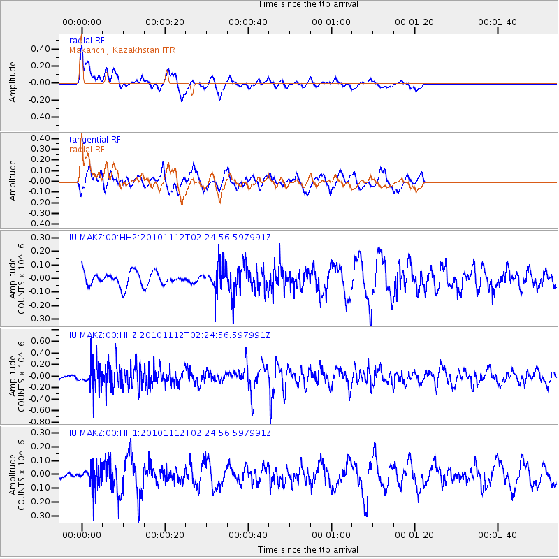
MAKZ Makanchi, Kazakhstan - Earthquake Result Viewer
*The percent match for this event was below the threshold and hence no stack was calculated.
| Earthquake location: |
Banda Sea |
| Earthquake latitude/longitude: |
-6.6/130.0 |
| Earthquake time(UTC): |
2010/11/12 (316) 02:14:46 GMT |
| Earthquake Depth: |
169 km |
| Earthquake Magnitude: |
5.7 MB, 5.5 MW, 5.5 MW |
| Earthquake Catalog/Contributor: |
WHDF/NEIC |
|
| Network: |
IU Global Seismograph Network (GSN - IRIS/USGS) |
| Station: |
MAKZ Makanchi, Kazakhstan |
| Lat/Lon: |
46.81 N/81.98 E |
| Elevation: |
600 m |
|
| Distance: |
68.1 deg |
| Az: |
326.575 deg |
| Baz: |
127.177 deg |
| Ray Param: |
$rayparam |
*The percent match for this event was below the threshold and hence was not used in the summary stack. |
|
| Radial Match: |
65.60275 % |
| Radial Bump: |
375 |
| Transverse Match: |
55.986496 % |
| Transverse Bump: |
400 |
| SOD ConfigId: |
617450 |
| Insert Time: |
2013-10-01 14:18:06.569 +0000 |
| GWidth: |
2.5 |
| Max Bumps: |
400 |
| Tol: |
0.001 |
|
Signal To Noise
| Channel | StoN | STA | LTA |
| IU:MAKZ:00:HHZ:20101112T02:24:56.597991Z | 1.6606984 | 2.058035E-7 | 1.2392587E-7 |
| IU:MAKZ:00:HH1:20101112T02:24:56.597991Z | 0.70194906 | 7.743039E-8 | 1.103077E-7 |
| IU:MAKZ:00:HH2:20101112T02:24:56.597991Z | 1.7396879 | 8.665716E-8 | 4.98119E-8 |
| Arrivals |
| Ps | |
| PpPs | |
| PsPs/PpSs | |


