You are here: Home > Network List > II - Global Seismograph Network (GSN - IRIS/IDA) Stations List
> Station MSEY Mahe, Seychelles > Earthquake Result Viewer
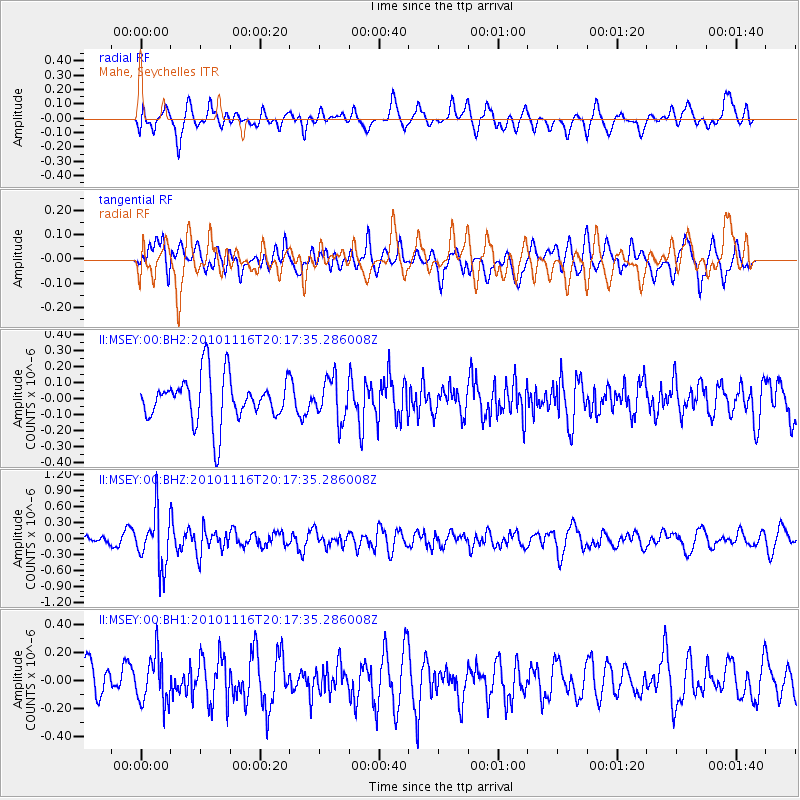
MSEY Mahe, Seychelles - Earthquake Result Viewer
*The percent match for this event was below the threshold and hence no stack was calculated.
| Earthquake location: |
Banda Sea |
| Earthquake latitude/longitude: |
-5.9/130.7 |
| Earthquake time(UTC): |
2010/11/16 (320) 20:06:38 GMT |
| Earthquake Depth: |
119 km |
| Earthquake Magnitude: |
5.8 MB, 5.4 MW, 5.4 MW |
| Earthquake Catalog/Contributor: |
WHDF/NEIC |
|
| Network: |
II Global Seismograph Network (GSN - IRIS/IDA) |
| Station: |
MSEY Mahe, Seychelles |
| Lat/Lon: |
4.67 S/55.48 E |
| Elevation: |
475 m |
|
| Distance: |
74.9 deg |
| Az: |
266.759 deg |
| Baz: |
94.825 deg |
| Ray Param: |
$rayparam |
*The percent match for this event was below the threshold and hence was not used in the summary stack. |
|
| Radial Match: |
61.174152 % |
| Radial Bump: |
400 |
| Transverse Match: |
52.90966 % |
| Transverse Bump: |
400 |
| SOD ConfigId: |
617450 |
| Insert Time: |
2013-10-01 14:30:03.880 +0000 |
| GWidth: |
2.5 |
| Max Bumps: |
400 |
| Tol: |
0.001 |
|
Signal To Noise
| Channel | StoN | STA | LTA |
| II:MSEY:00:BHZ:20101116T20:17:35.286008Z | 3.9017737 | 5.081125E-7 | 1.3022604E-7 |
| II:MSEY:00:BH1:20101116T20:17:35.286008Z | 1.3512927 | 1.7255753E-7 | 1.2769812E-7 |
| II:MSEY:00:BH2:20101116T20:17:35.286008Z | 0.89688367 | 1.296748E-7 | 1.4458375E-7 |
| Arrivals |
| Ps | |
| PpPs | |
| PsPs/PpSs | |


