You are here: Home > Network List > IU - Global Seismograph Network (GSN - IRIS/USGS) Stations List
> Station HNR Honiara, Solomon Islands > Earthquake Result Viewer
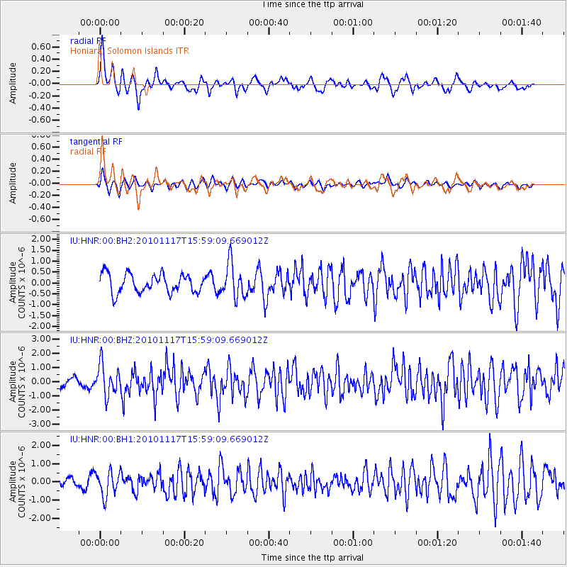
HNR Honiara, Solomon Islands - Earthquake Result Viewer
*The percent match for this event was below the threshold and hence no stack was calculated.
| Earthquake location: |
Banda Sea |
| Earthquake latitude/longitude: |
-7.8/129.4 |
| Earthquake time(UTC): |
2010/11/17 (321) 15:53:31 GMT |
| Earthquake Depth: |
23 km |
| Earthquake Magnitude: |
5.6 MB, 5.7 MS, 5.9 MW, 5.8 MW |
| Earthquake Catalog/Contributor: |
WHDF/NEIC |
|
| Network: |
IU Global Seismograph Network (GSN - IRIS/USGS) |
| Station: |
HNR Honiara, Solomon Islands |
| Lat/Lon: |
9.44 S/159.95 E |
| Elevation: |
100 m |
|
| Distance: |
30.2 deg |
| Az: |
95.347 deg |
| Baz: |
270.698 deg |
| Ray Param: |
$rayparam |
*The percent match for this event was below the threshold and hence was not used in the summary stack. |
|
| Radial Match: |
79.376625 % |
| Radial Bump: |
371 |
| Transverse Match: |
69.38148 % |
| Transverse Bump: |
392 |
| SOD ConfigId: |
617450 |
| Insert Time: |
2013-10-01 14:32:12.039 +0000 |
| GWidth: |
2.5 |
| Max Bumps: |
400 |
| Tol: |
0.001 |
|
Signal To Noise
| Channel | StoN | STA | LTA |
| IU:HNR:00:BHZ:20101117T15:59:09.669012Z | 4.299483 | 1.1052252E-6 | 2.5706007E-7 |
| IU:HNR:00:BH1:20101117T15:59:09.669012Z | 2.297649 | 6.8023377E-7 | 2.9605647E-7 |
| IU:HNR:00:BH2:20101117T15:59:09.669012Z | 1.8834288 | 8.103374E-7 | 4.3024582E-7 |
| Arrivals |
| Ps | |
| PpPs | |
| PsPs/PpSs | |


