You are here: Home > Network List > IU - Global Seismograph Network (GSN - IRIS/USGS) Stations List
> Station HNR Honiara, Solomon Islands > Earthquake Result Viewer
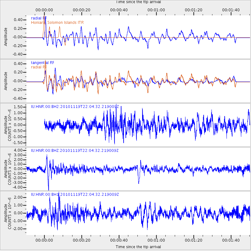
HNR Honiara, Solomon Islands - Earthquake Result Viewer
*The percent match for this event was below the threshold and hence no stack was calculated.
| Earthquake location: |
Northern Sumatra, Indonesia |
| Earthquake latitude/longitude: |
1.2/100.1 |
| Earthquake time(UTC): |
2010/11/19 (323) 21:55:15 GMT |
| Earthquake Depth: |
213 km |
| Earthquake Magnitude: |
5.5 MB, 5.7 MW, 5.6 MW |
| Earthquake Catalog/Contributor: |
WHDF/NEIC |
|
| Network: |
IU Global Seismograph Network (GSN - IRIS/USGS) |
| Station: |
HNR Honiara, Solomon Islands |
| Lat/Lon: |
9.44 S/159.95 E |
| Elevation: |
100 m |
|
| Distance: |
60.5 deg |
| Az: |
101.468 deg |
| Baz: |
276.735 deg |
| Ray Param: |
$rayparam |
*The percent match for this event was below the threshold and hence was not used in the summary stack. |
|
| Radial Match: |
75.0573 % |
| Radial Bump: |
400 |
| Transverse Match: |
78.83133 % |
| Transverse Bump: |
400 |
| SOD ConfigId: |
617450 |
| Insert Time: |
2013-10-01 14:33:58.069 +0000 |
| GWidth: |
2.5 |
| Max Bumps: |
400 |
| Tol: |
0.001 |
|
Signal To Noise
| Channel | StoN | STA | LTA |
| IU:HNR:00:BHZ:20101119T22:04:32.219009Z | 5.532455 | 1.5129754E-6 | 2.734727E-7 |
| IU:HNR:00:BH1:20101119T22:04:32.219009Z | 2.5637376 | 7.530317E-7 | 2.9372416E-7 |
| IU:HNR:00:BH2:20101119T22:04:32.219009Z | 2.1548016 | 5.650046E-7 | 2.6220727E-7 |
| Arrivals |
| Ps | |
| PpPs | |
| PsPs/PpSs | |


