You are here: Home > Network List > IU - Global Seismograph Network (GSN - IRIS/USGS) Stations List
> Station MAKZ Makanchi, Kazakhstan > Earthquake Result Viewer
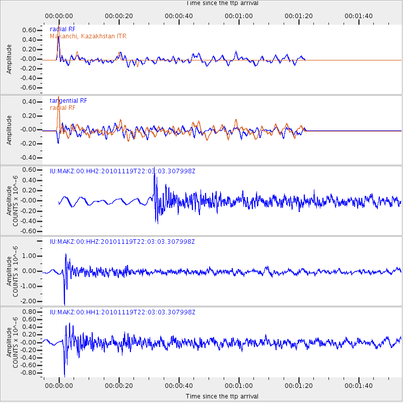
MAKZ Makanchi, Kazakhstan - Earthquake Result Viewer
*The percent match for this event was below the threshold and hence no stack was calculated.
| Earthquake location: |
Northern Sumatra, Indonesia |
| Earthquake latitude/longitude: |
1.2/100.1 |
| Earthquake time(UTC): |
2010/11/19 (323) 21:55:15 GMT |
| Earthquake Depth: |
213 km |
| Earthquake Magnitude: |
5.5 MB, 5.7 MW, 5.6 MW |
| Earthquake Catalog/Contributor: |
WHDF/NEIC |
|
| Network: |
IU Global Seismograph Network (GSN - IRIS/USGS) |
| Station: |
MAKZ Makanchi, Kazakhstan |
| Lat/Lon: |
46.81 N/81.98 E |
| Elevation: |
600 m |
|
| Distance: |
48.1 deg |
| Az: |
343.308 deg |
| Baz: |
155.287 deg |
| Ray Param: |
$rayparam |
*The percent match for this event was below the threshold and hence was not used in the summary stack. |
|
| Radial Match: |
70.86638 % |
| Radial Bump: |
400 |
| Transverse Match: |
53.06182 % |
| Transverse Bump: |
400 |
| SOD ConfigId: |
617450 |
| Insert Time: |
2013-10-01 14:34:03.027 +0000 |
| GWidth: |
2.5 |
| Max Bumps: |
400 |
| Tol: |
0.001 |
|
Signal To Noise
| Channel | StoN | STA | LTA |
| IU:MAKZ:00:HHZ:20101119T22:03:03.307998Z | 10.936947 | 5.7221604E-7 | 5.2319542E-8 |
| IU:MAKZ:00:HH1:20101119T22:03:03.307998Z | 5.311754 | 2.6147572E-7 | 4.9225868E-8 |
| IU:MAKZ:00:HH2:20101119T22:03:03.307998Z | 4.1560035 | 2.0153024E-7 | 4.8491355E-8 |
| Arrivals |
| Ps | |
| PpPs | |
| PsPs/PpSs | |


