You are here: Home > Network List > IU - Global Seismograph Network (GSN - IRIS/USGS) Stations List
> Station HNR Honiara, Solomon Islands > Earthquake Result Viewer
HNR Honiara, Solomon Islands - Earthquake Result Viewer
| Earthquake location: |
Taiwan |
| Earthquake latitude/longitude: |
23.8/121.7 |
| Earthquake time(UTC): |
2010/11/21 (325) 12:31:45 GMT |
| Earthquake Depth: |
47 km |
| Earthquake Magnitude: |
5.6 MB, 5.1 MS, 5.6 MW, 5.5 MW |
| Earthquake Catalog/Contributor: |
WHDF/NEIC |
|
| Network: |
IU Global Seismograph Network (GSN - IRIS/USGS) |
| Station: |
HNR Honiara, Solomon Islands |
| Lat/Lon: |
9.44 S/159.95 E |
| Elevation: |
100 m |
|
| Distance: |
49.9 deg |
| Az: |
126.976 deg |
| Baz: |
312.14 deg |
| Ray Param: |
0.068274245 |
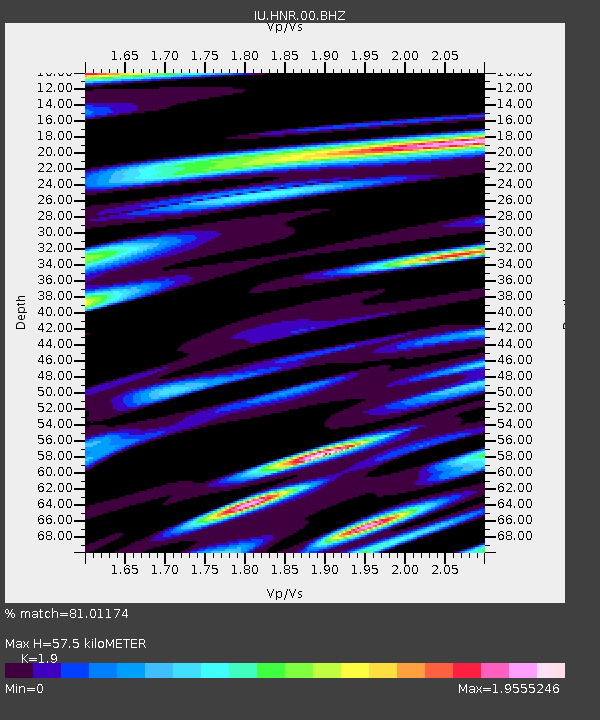
| Estimated Moho Depth: |
57.5 km |
| Estimated Crust Vp/Vs: |
1.90 |
| Assumed Crust Vp: |
6.183 km/s |
| Estimated Crust Vs: |
3.254 km/s |
| Estimated Crust Poisson's Ratio: |
0.31 |
|
| Radial Match: |
81.01174 % |
| Radial Bump: |
400 |
| Transverse Match: |
73.813095 % |
| Transverse Bump: |
400 |
| SOD ConfigId: |
617450 |
| Insert Time: |
2013-10-01 14:39:07.249 +0000 |
| GWidth: |
2.5 |
| Max Bumps: |
400 |
| Tol: |
0.001 |
|
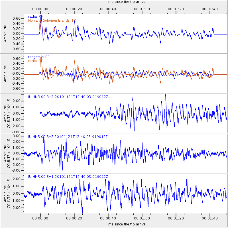
Signal To Noise
| Channel | StoN | STA | LTA |
| IU:HNR:00:BHZ:20101121T12:40:03.919012Z | 4.492535 | 1.129313E-6 | 2.5137544E-7 |
| IU:HNR:00:BH1:20101121T12:40:03.919012Z | 3.2930298 | 7.489538E-7 | 2.2743609E-7 |
| IU:HNR:00:BH2:20101121T12:40:03.919012Z | 2.1592276 | 5.5018234E-7 | 2.5480517E-7 |
| Arrivals |
| Ps | 8.8 SECOND |
| PpPs | 26 SECOND |
| PsPs/PpSs | 34 SECOND |


