You are here: Home > Network List > II - Global Seismograph Network (GSN - IRIS/IDA) Stations List
> Station AAK Ala Archa, Kyrgyzstan > Earthquake Result Viewer
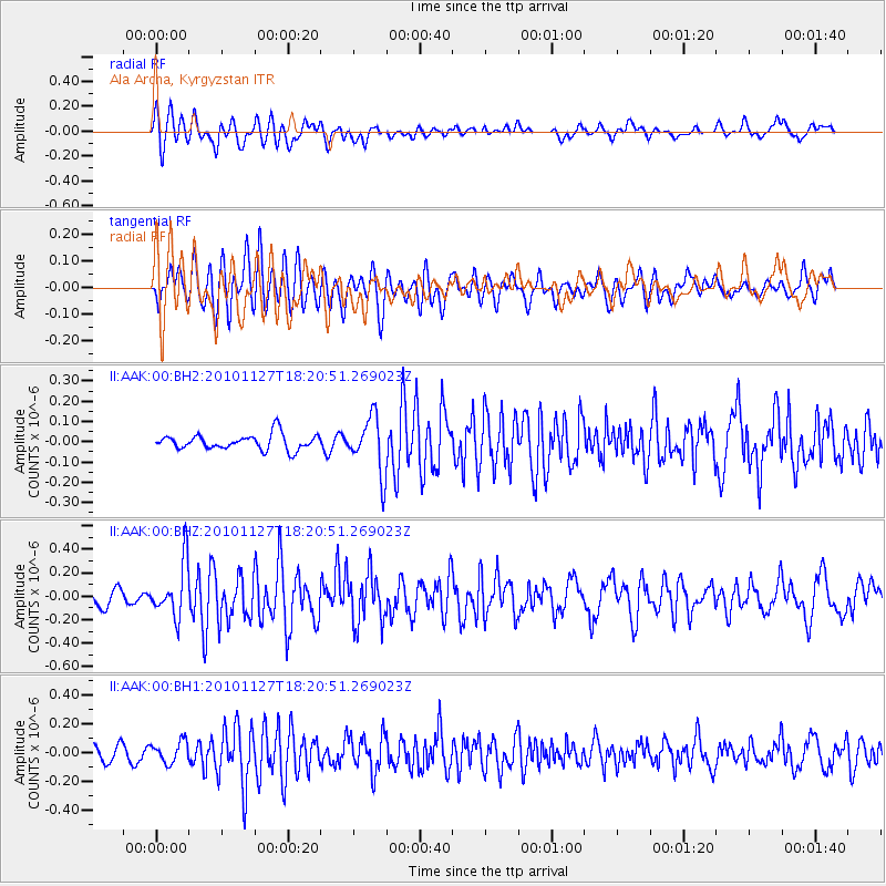
AAK Ala Archa, Kyrgyzstan - Earthquake Result Viewer
*The percent match for this event was below the threshold and hence no stack was calculated.
| Earthquake location: |
North Of Halmahera, Indonesia |
| Earthquake latitude/longitude: |
3.9/128.1 |
| Earthquake time(UTC): |
2010/11/27 (331) 18:11:13 GMT |
| Earthquake Depth: |
59 km |
| Earthquake Magnitude: |
5.9 MB, 5.7 MW, 5.6 MW |
| Earthquake Catalog/Contributor: |
WHDF/NEIC |
|
| Network: |
II Global Seismograph Network (GSN - IRIS/IDA) |
| Station: |
AAK Ala Archa, Kyrgyzstan |
| Lat/Lon: |
42.64 N/74.49 E |
| Elevation: |
1645 m |
|
| Distance: |
61.2 deg |
| Az: |
317.328 deg |
| Baz: |
113.582 deg |
| Ray Param: |
$rayparam |
*The percent match for this event was below the threshold and hence was not used in the summary stack. |
|
| Radial Match: |
69.671684 % |
| Radial Bump: |
400 |
| Transverse Match: |
62.69251 % |
| Transverse Bump: |
400 |
| SOD ConfigId: |
617450 |
| Insert Time: |
2013-10-01 14:51:18.190 +0000 |
| GWidth: |
2.5 |
| Max Bumps: |
400 |
| Tol: |
0.001 |
|
Signal To Noise
| Channel | StoN | STA | LTA |
| II:AAK:00:BHZ:20101127T18:20:51.269023Z | 2.9121585 | 2.3010881E-7 | 7.901658E-8 |
| II:AAK:00:BH1:20101127T18:20:51.269023Z | 1.248987 | 7.3676475E-8 | 5.8988984E-8 |
| II:AAK:00:BH2:20101127T18:20:51.269023Z | 3.66166 | 1.3881595E-7 | 3.7910663E-8 |
| Arrivals |
| Ps | |
| PpPs | |
| PsPs/PpSs | |


