You are here: Home > Network List > IU - Global Seismograph Network (GSN - IRIS/USGS) Stations List
> Station MAKZ Makanchi, Kazakhstan > Earthquake Result Viewer
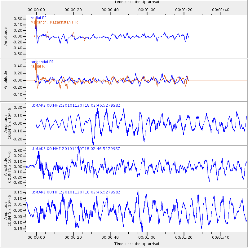
MAKZ Makanchi, Kazakhstan - Earthquake Result Viewer
*The percent match for this event was below the threshold and hence no stack was calculated.
| Earthquake location: |
Kuril Islands |
| Earthquake latitude/longitude: |
48.9/154.9 |
| Earthquake time(UTC): |
2010/11/30 (334) 17:54:47 GMT |
| Earthquake Depth: |
35 km |
| Earthquake Magnitude: |
5.7 MW, 5.2 MS, 5.4 MB, 5.6 MW |
| Earthquake Catalog/Contributor: |
WHDF/NEIC |
|
| Network: |
IU Global Seismograph Network (GSN - IRIS/USGS) |
| Station: |
MAKZ Makanchi, Kazakhstan |
| Lat/Lon: |
46.81 N/81.98 E |
| Elevation: |
600 m |
|
| Distance: |
47.2 deg |
| Az: |
296.536 deg |
| Baz: |
59.216 deg |
| Ray Param: |
$rayparam |
*The percent match for this event was below the threshold and hence was not used in the summary stack. |
|
| Radial Match: |
67.90833 % |
| Radial Bump: |
393 |
| Transverse Match: |
62.05733 % |
| Transverse Bump: |
362 |
| SOD ConfigId: |
617450 |
| Insert Time: |
2013-10-01 14:59:45.452 +0000 |
| GWidth: |
2.5 |
| Max Bumps: |
400 |
| Tol: |
0.001 |
|
Signal To Noise
| Channel | StoN | STA | LTA |
| IU:MAKZ:00:HHZ:20101130T18:02:46.527998Z | 2.0446913 | 1.3279475E-7 | 6.494611E-8 |
| IU:MAKZ:00:HH1:20101130T18:02:46.527998Z | 0.6798417 | 3.890031E-8 | 5.721966E-8 |
| IU:MAKZ:00:HH2:20101130T18:02:46.527998Z | 2.3749516 | 1.3495182E-7 | 5.6822977E-8 |
| Arrivals |
| Ps | |
| PpPs | |
| PsPs/PpSs | |


