You are here: Home > Network List > IU - Global Seismograph Network (GSN - IRIS/USGS) Stations List
> Station HNR Honiara, Solomon Islands > Earthquake Result Viewer
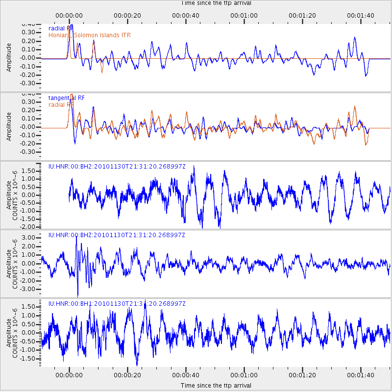
HNR Honiara, Solomon Islands - Earthquake Result Viewer
*The percent match for this event was below the threshold and hence no stack was calculated.
| Earthquake location: |
South Indian Ocean |
| Earthquake latitude/longitude: |
-4.1/79.8 |
| Earthquake time(UTC): |
2010/11/30 (334) 21:19:44 GMT |
| Earthquake Depth: |
10 km |
| Earthquake Magnitude: |
5.6 MB, 5.2 MW |
| Earthquake Catalog/Contributor: |
WHDF/NEIC |
|
| Network: |
IU Global Seismograph Network (GSN - IRIS/USGS) |
| Station: |
HNR Honiara, Solomon Islands |
| Lat/Lon: |
9.44 S/159.95 E |
| Elevation: |
100 m |
|
| Distance: |
79.6 deg |
| Az: |
98.801 deg |
| Baz: |
267.542 deg |
| Ray Param: |
$rayparam |
*The percent match for this event was below the threshold and hence was not used in the summary stack. |
|
| Radial Match: |
52.309704 % |
| Radial Bump: |
400 |
| Transverse Match: |
69.7951 % |
| Transverse Bump: |
400 |
| SOD ConfigId: |
617450 |
| Insert Time: |
2013-10-01 15:01:26.730 +0000 |
| GWidth: |
2.5 |
| Max Bumps: |
400 |
| Tol: |
0.001 |
|
Signal To Noise
| Channel | StoN | STA | LTA |
| IU:HNR:00:BHZ:20101130T21:31:20.268997Z | 2.5066571 | 1.4279261E-6 | 5.696536E-7 |
| IU:HNR:00:BH1:20101130T21:31:20.268997Z | 1.1544813 | 6.122697E-7 | 5.3034177E-7 |
| IU:HNR:00:BH2:20101130T21:31:20.268997Z | 1.2950788 | 5.383365E-7 | 4.1567856E-7 |
| Arrivals |
| Ps | |
| PpPs | |
| PsPs/PpSs | |


