You are here: Home > Network List > IU - Global Seismograph Network (GSN - IRIS/USGS) Stations List
> Station HNR Honiara, Solomon Islands > Earthquake Result Viewer
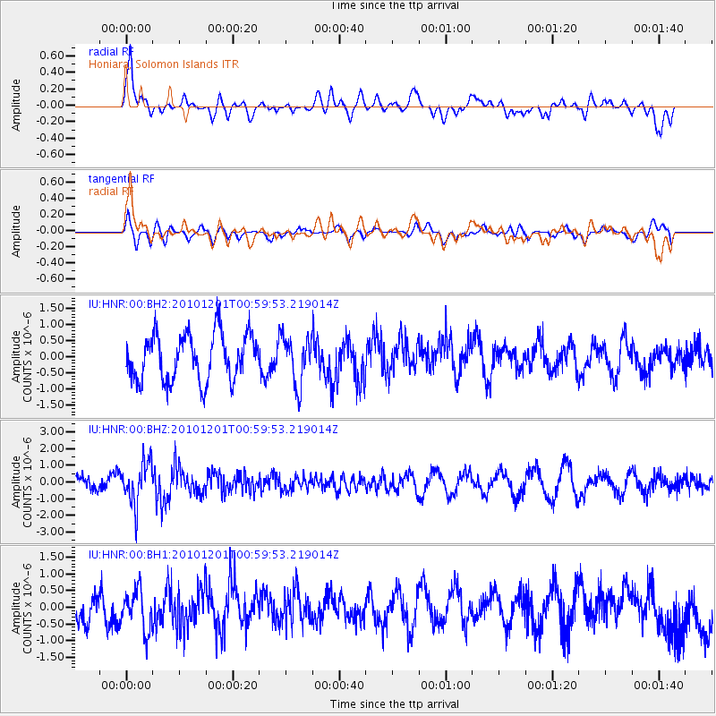
HNR Honiara, Solomon Islands - Earthquake Result Viewer
*The percent match for this event was below the threshold and hence no stack was calculated.
| Earthquake location: |
Northern Sumatra, Indonesia |
| Earthquake latitude/longitude: |
2.7/99.0 |
| Earthquake time(UTC): |
2010/12/01 (335) 00:50:21 GMT |
| Earthquake Depth: |
160 km |
| Earthquake Magnitude: |
5.5 MW, 5.4 MB, 5.5 MW |
| Earthquake Catalog/Contributor: |
WHDF/NEIC |
|
| Network: |
IU Global Seismograph Network (GSN - IRIS/USGS) |
| Station: |
HNR Honiara, Solomon Islands |
| Lat/Lon: |
9.44 S/159.95 E |
| Elevation: |
100 m |
|
| Distance: |
61.9 deg |
| Az: |
102.117 deg |
| Baz: |
278.157 deg |
| Ray Param: |
$rayparam |
*The percent match for this event was below the threshold and hence was not used in the summary stack. |
|
| Radial Match: |
65.63018 % |
| Radial Bump: |
400 |
| Transverse Match: |
55.424458 % |
| Transverse Bump: |
400 |
| SOD ConfigId: |
617450 |
| Insert Time: |
2013-10-01 15:03:52.309 +0000 |
| GWidth: |
2.5 |
| Max Bumps: |
400 |
| Tol: |
0.001 |
|
Signal To Noise
| Channel | StoN | STA | LTA |
| IU:HNR:00:BHZ:20101201T00:59:53.219014Z | 3.0737305 | 1.2444141E-6 | 4.0485466E-7 |
| IU:HNR:00:BH1:20101201T00:59:53.219014Z | 1.5917257 | 6.174712E-7 | 3.879256E-7 |
| IU:HNR:00:BH2:20101201T00:59:53.219014Z | 1.031561 | 7.347505E-7 | 7.122705E-7 |
| Arrivals |
| Ps | |
| PpPs | |
| PsPs/PpSs | |


