You are here: Home > Network List > II - Global Seismograph Network (GSN - IRIS/IDA) Stations List
> Station WRAB Tennant Creek, NT, Australia > Earthquake Result Viewer
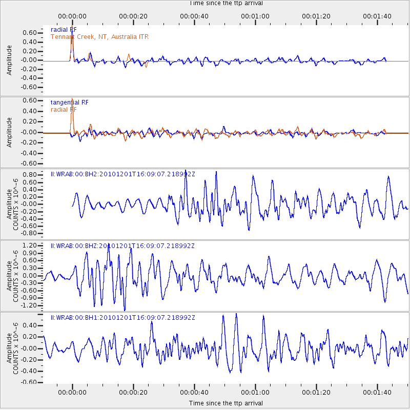
WRAB Tennant Creek, NT, Australia - Earthquake Result Viewer
*The percent match for this event was below the threshold and hence no stack was calculated.
| Earthquake location: |
Fiji Islands Region |
| Earthquake latitude/longitude: |
-15.9/-179.0 |
| Earthquake time(UTC): |
2010/12/01 (335) 16:01:27 GMT |
| Earthquake Depth: |
15 km |
| Earthquake Magnitude: |
5.6 MB, 5.9 MS, 6.1 MW, 6.0 MW |
| Earthquake Catalog/Contributor: |
WHDF/NEIC |
|
| Network: |
II Global Seismograph Network (GSN - IRIS/IDA) |
| Station: |
WRAB Tennant Creek, NT, Australia |
| Lat/Lon: |
19.93 S/134.36 E |
| Elevation: |
366 m |
|
| Distance: |
44.5 deg |
| Az: |
257.597 deg |
| Baz: |
92.636 deg |
| Ray Param: |
$rayparam |
*The percent match for this event was below the threshold and hence was not used in the summary stack. |
|
| Radial Match: |
78.578415 % |
| Radial Bump: |
400 |
| Transverse Match: |
48.4066 % |
| Transverse Bump: |
400 |
| SOD ConfigId: |
617450 |
| Insert Time: |
2013-10-01 15:05:33.608 +0000 |
| GWidth: |
2.5 |
| Max Bumps: |
400 |
| Tol: |
0.001 |
|
Signal To Noise
| Channel | StoN | STA | LTA |
| II:WRAB:00:BHZ:20101201T16:09:07.218992Z | 2.995659 | 4.7612585E-7 | 1.589386E-7 |
| II:WRAB:00:BH1:20101201T16:09:07.218992Z | 0.7668968 | 1.12167044E-7 | 1.4626094E-7 |
| II:WRAB:00:BH2:20101201T16:09:07.218992Z | 1.6510165 | 2.2502736E-7 | 1.3629626E-7 |
| Arrivals |
| Ps | |
| PpPs | |
| PsPs/PpSs | |


