You are here: Home > Network List > IU - Global Seismograph Network (GSN - IRIS/USGS) Stations List
> Station RSSD Black Hills, South Dakota, USA > Earthquake Result Viewer
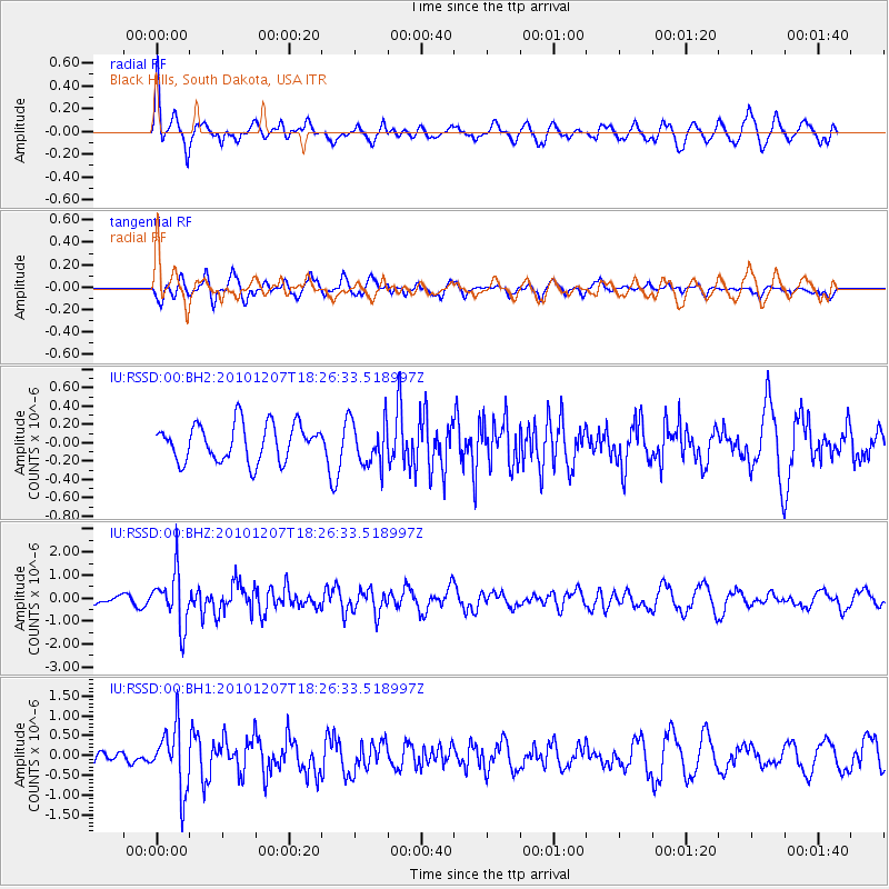
RSSD Black Hills, South Dakota, USA - Earthquake Result Viewer
*The percent match for this event was below the threshold and hence no stack was calculated.
| Earthquake location: |
Komandorskiye Ostrova Region |
| Earthquake latitude/longitude: |
54.4/169.1 |
| Earthquake time(UTC): |
2010/12/07 (341) 18:17:39 GMT |
| Earthquake Depth: |
10 km |
| Earthquake Magnitude: |
6.1 MB, 5.5 MS, 5.8 MW, 5.8 MW |
| Earthquake Catalog/Contributor: |
WHDF/NEIC |
|
| Network: |
IU Global Seismograph Network (GSN - IRIS/USGS) |
| Station: |
RSSD Black Hills, South Dakota, USA |
| Lat/Lon: |
44.12 N/104.04 W |
| Elevation: |
2090 m |
|
| Distance: |
54.1 deg |
| Az: |
62.528 deg |
| Baz: |
313.863 deg |
| Ray Param: |
$rayparam |
*The percent match for this event was below the threshold and hence was not used in the summary stack. |
|
| Radial Match: |
60.972614 % |
| Radial Bump: |
400 |
| Transverse Match: |
71.27728 % |
| Transverse Bump: |
400 |
| SOD ConfigId: |
617450 |
| Insert Time: |
2013-10-01 15:18:32.972 +0000 |
| GWidth: |
2.5 |
| Max Bumps: |
400 |
| Tol: |
0.001 |
|
Signal To Noise
| Channel | StoN | STA | LTA |
| IU:RSSD:00:BHZ:20101207T18:26:33.518997Z | 4.208893 | 1.1354368E-6 | 2.697709E-7 |
| IU:RSSD:00:BH1:20101207T18:26:33.518997Z | 3.4638388 | 7.8997897E-7 | 2.2806458E-7 |
| IU:RSSD:00:BH2:20101207T18:26:33.518997Z | 1.2110511 | 2.4255772E-7 | 2.0028693E-7 |
| Arrivals |
| Ps | |
| PpPs | |
| PsPs/PpSs | |


