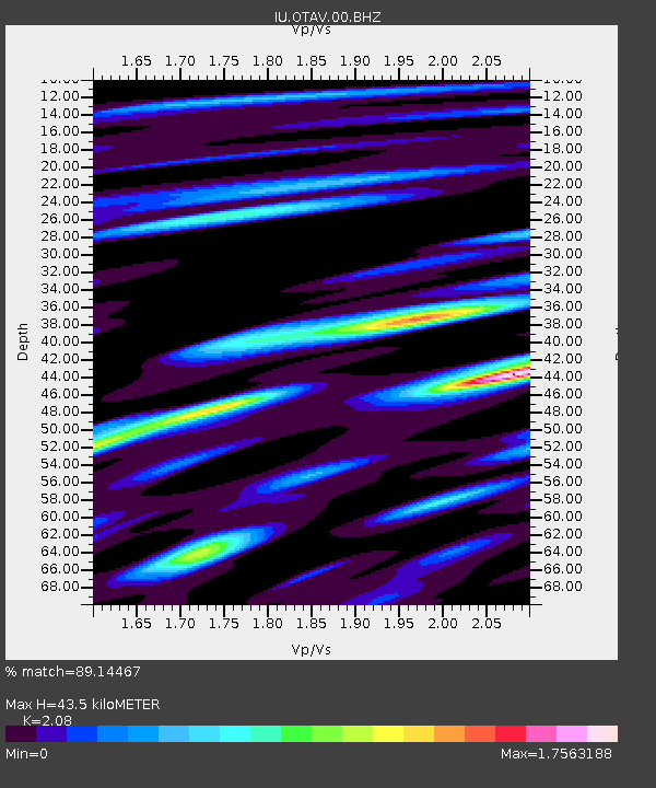
OTAV Otavalo, Ecuador - Earthquake Result Viewer
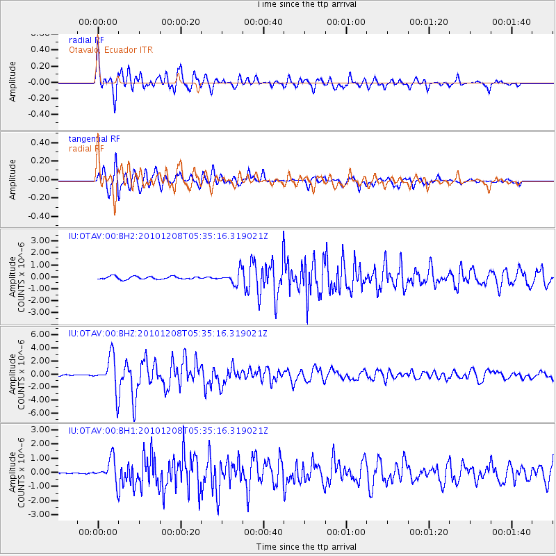
Earthquake location: South Sandwich Islands Region
Earthquake latitude/longitude: -56.4/-25.7
Earthquake time(UTC): 2010/12/08 (342) 05:24:35 GMT
Earthquake Depth: 29 km
Earthquake Magnitude: 6.1 MB, 6.2 MS, 6.3 MW, 6.3 MW
Earthquake Catalog/Contributor: WHDF/NEIC
Network: IU Global Seismograph Network (GSN - IRIS/USGS)
Station: OTAV Otavalo, Ecuador
Lat/Lon: 0.24 N/78.45 W
Elevation: 3510 m
Distance: 70.5 deg
Az: 302.454 deg
Baz: 152.031 deg
Ray Param: 0.05487989
Estimated Moho Depth: 43.5 km
Estimated Crust Vp/Vs: 2.08
Assumed Crust Vp: 6.472 km/s
Estimated Crust Vs: 3.111 km/s
Estimated Crust Poisson's Ratio: 0.35
Radial Match: 89.14467 %
Radial Bump: 400
Transverse Match: 91.292114 %
Transverse Bump: 400
SOD ConfigId: 617450
Insert Time: 2013-10-01 15:20:37.805 +0000
GWidth: 2.5
Max Bumps: 400
Tol: 0.001

Signal To Noise

ChannelStoNSTALTA
IU:OTAV:00:BHZ:20101208T05:35:16.319021Z32.7468832.752456E-68.4052466E-8
IU:OTAV:00:BH1:20101208T05:35:16.319021Z17.105078.783468E-75.135008E-8
IU:OTAV:00:BH2:20101208T05:35:16.319021Z4.6151745.539507E-71.2002813E-7
Arrivals
Ps7.5 SECOND
PpPs20 SECOND
PsPs/PpSs28 SECOND