You are here: Home > Network List > ER - Mount Erebus Volcano Observatory Seismic Network Stations List
> Station HOO Hoopers Shoulder,Mt Erebus Volcano Observatory Network, > Earthquake Result Viewer
HOO Hoopers Shoulder,Mt Erebus Volcano Observatory Network, - Earthquake Result Viewer
| Earthquake location: |
Solomon Islands |
| Earthquake latitude/longitude: |
-6.5/155.6 |
| Earthquake time(UTC): |
2010/12/13 (347) 01:14:42 GMT |
| Earthquake Depth: |
136 km |
| Earthquake Magnitude: |
6.2 MW, 6.2 MB, 6.2 MW |
| Earthquake Catalog/Contributor: |
NEIC PDE/NEIC PDE-M |
|
| Network: |
ER Mount Erebus Volcano Observatory Seismic Network |
| Station: |
HOO Hoopers Shoulder,Mt Erebus Volcano Observatory Network, |
| Lat/Lon: |
77.53 S/166.93 E |
| Elevation: |
2069 m |
|
| Distance: |
71.2 deg |
| Az: |
177.426 deg |
| Baz: |
348.148 deg |
| Ray Param: |
0.054122604 |
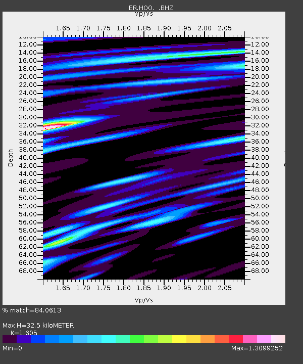
| Estimated Moho Depth: |
32.5 km |
| Estimated Crust Vp/Vs: |
1.61 |
| Assumed Crust Vp: |
6.183 km/s |
| Estimated Crust Vs: |
3.852 km/s |
| Estimated Crust Poisson's Ratio: |
0.18 |
|
| Radial Match: |
84.0613 % |
| Radial Bump: |
400 |
| Transverse Match: |
78.032265 % |
| Transverse Bump: |
400 |
| SOD ConfigId: |
617450 |
| Insert Time: |
2013-10-01 15:33:49.209 +0000 |
| GWidth: |
2.5 |
| Max Bumps: |
400 |
| Tol: |
0.001 |
|

Signal To Noise
| Channel | StoN | STA | LTA |
| ER:HOO: :BHZ:20101213T01:25:15.650017Z | 20.946241 | 6.5508175E-6 | 3.127443E-7 |
| ER:HOO: :BH1:20101213T01:25:15.650017Z | 3.466899 | 1.2354527E-6 | 3.563567E-7 |
| ER:HOO: :BH2:20101213T01:25:15.650017Z | 7.1295075 | 2.7379012E-6 | 3.8402388E-7 |
| Arrivals |
| Ps | 3.3 SECOND |
| PpPs | 13 SECOND |
| PsPs/PpSs | 17 SECOND |


