You are here: Home > Network List > II - Global Seismograph Network (GSN - IRIS/IDA) Stations List
> Station PALK Pallekele, Sri Lanka > Earthquake Result Viewer
PALK Pallekele, Sri Lanka - Earthquake Result Viewer
| Earthquake location: |
Solomon Islands |
| Earthquake latitude/longitude: |
-6.5/155.6 |
| Earthquake time(UTC): |
2010/12/13 (347) 01:14:42 GMT |
| Earthquake Depth: |
136 km |
| Earthquake Magnitude: |
6.2 MW, 6.2 MB, 6.2 MW |
| Earthquake Catalog/Contributor: |
NEIC PDE/NEIC PDE-M |
|
| Network: |
II Global Seismograph Network (GSN - IRIS/IDA) |
| Station: |
PALK Pallekele, Sri Lanka |
| Lat/Lon: |
7.27 N/80.70 E |
| Elevation: |
460 m |
|
| Distance: |
76.0 deg |
| Az: |
279.137 deg |
| Baz: |
98.57 deg |
| Ray Param: |
0.050951406 |
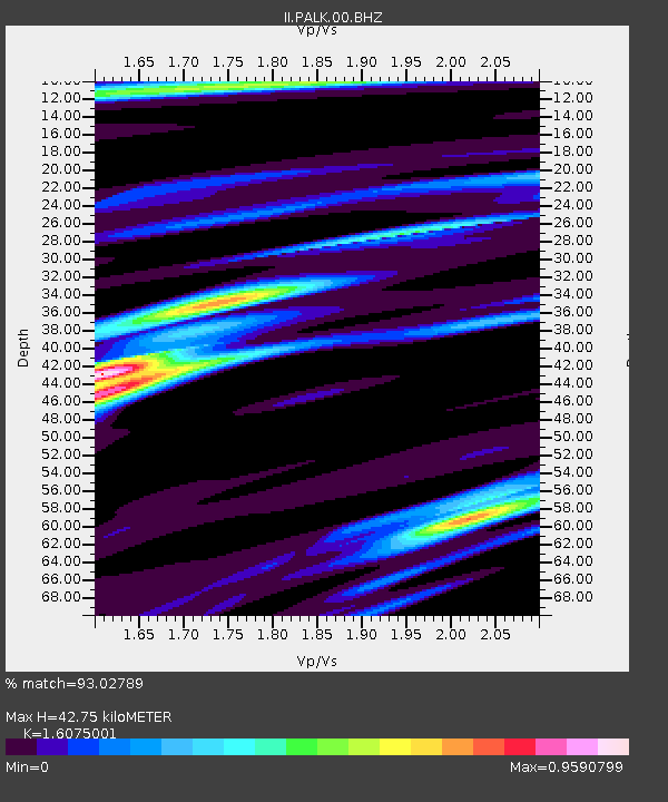
| Estimated Moho Depth: |
42.75 km |
| Estimated Crust Vp/Vs: |
1.61 |
| Assumed Crust Vp: |
6.545 km/s |
| Estimated Crust Vs: |
4.072 km/s |
| Estimated Crust Poisson's Ratio: |
0.18 |
|
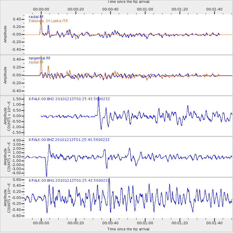
| Radial Match: |
93.02789 % |
| Radial Bump: |
400 |
| Transverse Match: |
83.42674 % |
| Transverse Bump: |
400 |
| SOD ConfigId: |
617450 |
| Insert Time: |
2013-10-01 15:34:01.677 +0000 |
| GWidth: |
2.5 |
| Max Bumps: |
400 |
| Tol: |
0.001 |
|
Signal To Noise
| Channel | StoN | STA | LTA |
| II:PALK:00:BHZ:20101213T01:25:43.569023Z | 15.9568815 | 1.7700777E-6 | 1.10928795E-7 |
| II:PALK:00:BH1:20101213T01:25:43.569023Z | 2.581768 | 2.005277E-7 | 7.7670684E-8 |
| II:PALK:00:BH2:20101213T01:25:43.569023Z | 8.996785 | 6.33506E-7 | 7.04147E-8 |
| Arrivals |
| Ps | 4.1 SECOND |
| PpPs | 16 SECOND |
| PsPs/PpSs | 21 SECOND |


