You are here: Home > Network List > IU - Global Seismograph Network (GSN - IRIS/USGS) Stations List
> Station SNZO South Karori, New Zealand > Earthquake Result Viewer
SNZO South Karori, New Zealand - Earthquake Result Viewer
| Earthquake location: |
Solomon Islands |
| Earthquake latitude/longitude: |
-6.5/155.6 |
| Earthquake time(UTC): |
2010/12/13 (347) 01:14:42 GMT |
| Earthquake Depth: |
136 km |
| Earthquake Magnitude: |
6.2 MW, 6.2 MB, 6.2 MW |
| Earthquake Catalog/Contributor: |
NEIC PDE/NEIC PDE-M |
|
| Network: |
IU Global Seismograph Network (GSN - IRIS/USGS) |
| Station: |
SNZO South Karori, New Zealand |
| Lat/Lon: |
41.31 S/174.70 E |
| Elevation: |
120 m |
|
| Distance: |
38.6 deg |
| Az: |
156.763 deg |
| Baz: |
328.645 deg |
| Ray Param: |
0.07500539 |
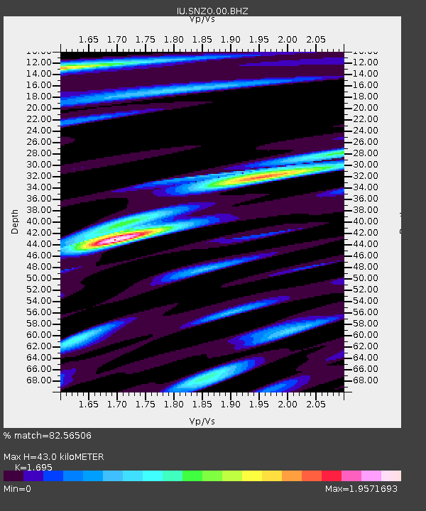
| Estimated Moho Depth: |
43.0 km |
| Estimated Crust Vp/Vs: |
1.70 |
| Assumed Crust Vp: |
6.461 km/s |
| Estimated Crust Vs: |
3.812 km/s |
| Estimated Crust Poisson's Ratio: |
0.23 |
|
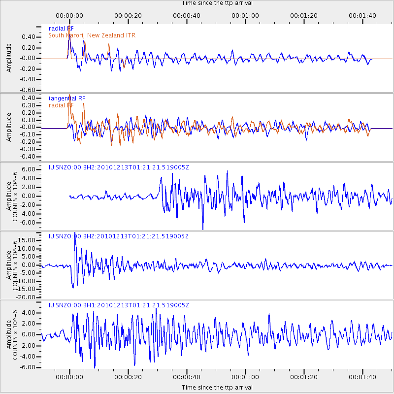
| Radial Match: |
82.56506 % |
| Radial Bump: |
400 |
| Transverse Match: |
79.89422 % |
| Transverse Bump: |
400 |
| SOD ConfigId: |
617450 |
| Insert Time: |
2013-10-01 15:34:20.204 +0000 |
| GWidth: |
2.5 |
| Max Bumps: |
400 |
| Tol: |
0.001 |
|
Signal To Noise
| Channel | StoN | STA | LTA |
| IU:SNZO:00:BHZ:20101213T01:21:21.519005Z | 20.876999 | 8.280511E-6 | 3.9663317E-7 |
| IU:SNZO:00:BH1:20101213T01:21:21.519005Z | 4.0585985 | 2.1853448E-6 | 5.3844815E-7 |
| IU:SNZO:00:BH2:20101213T01:21:21.519005Z | 6.3806615 | 2.248598E-6 | 3.524083E-7 |
| Arrivals |
| Ps | 5.0 SECOND |
| PpPs | 17 SECOND |
| PsPs/PpSs | 22 SECOND |


