You are here: Home > Network List > II - Global Seismograph Network (GSN - IRIS/IDA) Stations List
> Station WRAB Tennant Creek, NT, Australia > Earthquake Result Viewer
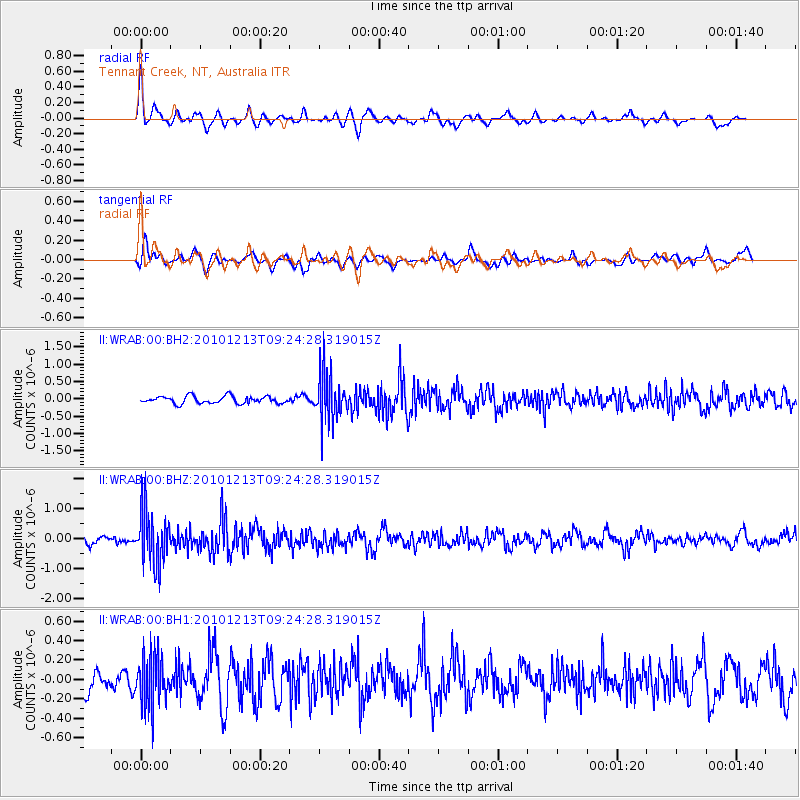
WRAB Tennant Creek, NT, Australia - Earthquake Result Viewer
*The percent match for this event was below the threshold and hence no stack was calculated.
| Earthquake location: |
Sunda Strait, Indonesia |
| Earthquake latitude/longitude: |
-6.3/104.0 |
| Earthquake time(UTC): |
2010/12/13 (347) 09:18:32 GMT |
| Earthquake Depth: |
43 km |
| Earthquake Magnitude: |
5.7 MB, 5.4 MS, 5.7 MW, 5.6 MW |
| Earthquake Catalog/Contributor: |
WHDF/NEIC |
|
| Network: |
II Global Seismograph Network (GSN - IRIS/IDA) |
| Station: |
WRAB Tennant Creek, NT, Australia |
| Lat/Lon: |
19.93 S/134.36 E |
| Elevation: |
366 m |
|
| Distance: |
32.5 deg |
| Az: |
117.643 deg |
| Baz: |
290.603 deg |
| Ray Param: |
$rayparam |
*The percent match for this event was below the threshold and hence was not used in the summary stack. |
|
| Radial Match: |
70.38788 % |
| Radial Bump: |
400 |
| Transverse Match: |
64.36662 % |
| Transverse Bump: |
400 |
| SOD ConfigId: |
617450 |
| Insert Time: |
2013-10-01 15:36:57.125 +0000 |
| GWidth: |
2.5 |
| Max Bumps: |
400 |
| Tol: |
0.001 |
|
Signal To Noise
| Channel | StoN | STA | LTA |
| II:WRAB:00:BHZ:20101213T09:24:28.319015Z | 7.2219114 | 8.730541E-7 | 1.2088961E-7 |
| II:WRAB:00:BH1:20101213T09:24:28.319015Z | 1.8420337 | 2.566784E-7 | 1.393451E-7 |
| II:WRAB:00:BH2:20101213T09:24:28.319015Z | 6.471988 | 6.716842E-7 | 1.0378328E-7 |
| Arrivals |
| Ps | |
| PpPs | |
| PsPs/PpSs | |


