You are here: Home > Network List > IU - Global Seismograph Network (GSN - IRIS/USGS) Stations List
> Station HNR Honiara, Solomon Islands > Earthquake Result Viewer
HNR Honiara, Solomon Islands - Earthquake Result Viewer
*The percent match for this event was below the threshold and hence no stack was calculated.
| Earthquake location: |
Sunda Strait, Indonesia |
| Earthquake latitude/longitude: |
-6.3/104.0 |
| Earthquake time(UTC): |
2010/12/13 (347) 09:18:32 GMT |
| Earthquake Depth: |
43 km |
| Earthquake Magnitude: |
5.7 MB, 5.4 MS, 5.7 MW, 5.6 MW |
| Earthquake Catalog/Contributor: |
WHDF/NEIC |
|
| Network: |
IU Global Seismograph Network (GSN - IRIS/USGS) |
| Station: |
HNR Honiara, Solomon Islands |
| Lat/Lon: |
9.44 S/159.95 E |
| Elevation: |
100 m |
|
| Distance: |
55.5 deg |
| Az: |
97.121 deg |
| Baz: |
268.877 deg |
| Ray Param: |
$rayparam |
*The percent match for this event was below the threshold and hence was not used in the summary stack. |
|
| Radial Match: |
68.45127 % |
| Radial Bump: |
400 |
| Transverse Match: |
64.02499 % |
| Transverse Bump: |
400 |
| SOD ConfigId: |
617450 |
| Insert Time: |
2013-10-01 15:37:02.017 +0000 |
| GWidth: |
2.5 |
| Max Bumps: |
400 |
| Tol: |
0.001 |
|
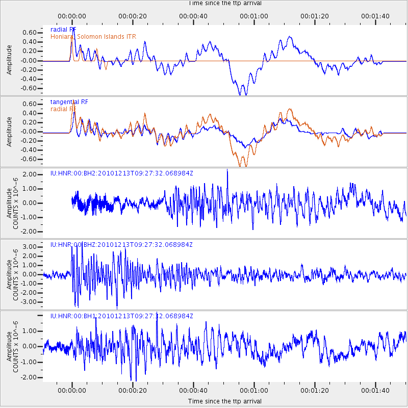
Signal To Noise
| Channel | StoN | STA | LTA |
| IU:HNR:00:BHZ:20101213T09:27:32.068984Z | 5.3266344 | 1.7353727E-6 | 3.257916E-7 |
| IU:HNR:00:BH1:20101213T09:27:32.068984Z | 1.3441991 | 5.3932166E-7 | 4.0122157E-7 |
| IU:HNR:00:BH2:20101213T09:27:32.068984Z | 1.8917731 | 6.2543705E-7 | 3.306089E-7 |
| Arrivals |
| Ps | |
| PpPs | |
| PsPs/PpSs | |


