You are here: Home > Network List > II - Global Seismograph Network (GSN - IRIS/IDA) Stations List
> Station CMLA Cha de Macela, Sao Miguel Island, Azores > Earthquake Result Viewer
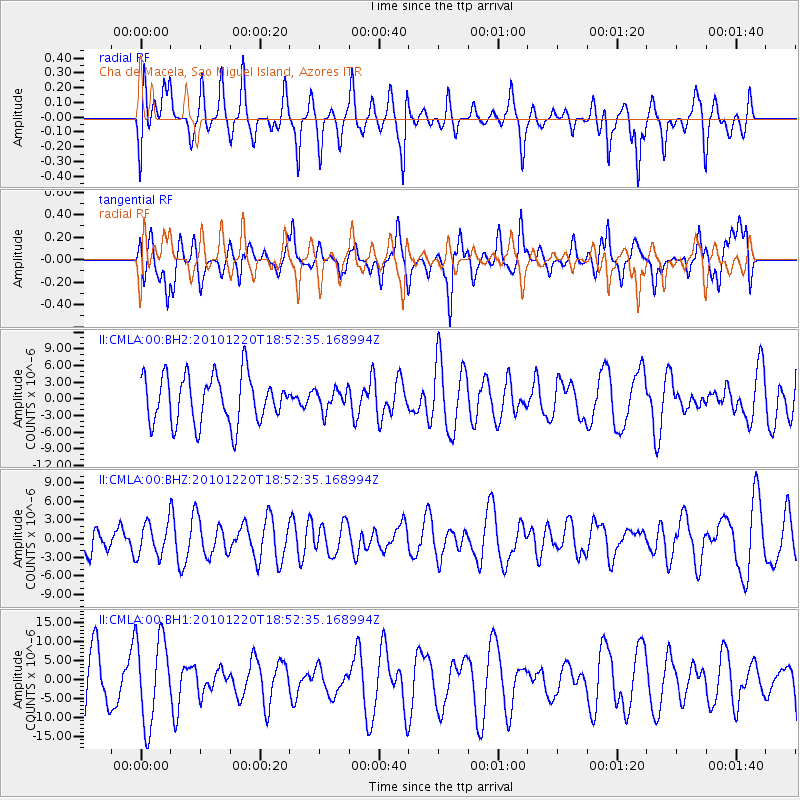
CMLA Cha de Macela, Sao Miguel Island, Azores - Earthquake Result Viewer
*The percent match for this event was below the threshold and hence no stack was calculated.
| Earthquake location: |
Southern Iran |
| Earthquake latitude/longitude: |
28.4/59.2 |
| Earthquake time(UTC): |
2010/12/20 (354) 18:41:59 GMT |
| Earthquake Depth: |
12 km |
| Earthquake Magnitude: |
6.5 MW, 6.1 MB, 6.7 MS, 6.7 MW |
| Earthquake Catalog/Contributor: |
NEIC PDE/NEIC PDE-M |
|
| Network: |
II Global Seismograph Network (GSN - IRIS/IDA) |
| Station: |
CMLA Cha de Macela, Sao Miguel Island, Azores |
| Lat/Lon: |
37.76 N/25.52 W |
| Elevation: |
429 m |
|
| Distance: |
69.3 deg |
| Az: |
302.491 deg |
| Baz: |
69.637 deg |
| Ray Param: |
$rayparam |
*The percent match for this event was below the threshold and hence was not used in the summary stack. |
|
| Radial Match: |
47.48928 % |
| Radial Bump: |
319 |
| Transverse Match: |
39.97529 % |
| Transverse Bump: |
340 |
| SOD ConfigId: |
617450 |
| Insert Time: |
2013-10-01 15:49:03.885 +0000 |
| GWidth: |
2.5 |
| Max Bumps: |
400 |
| Tol: |
0.001 |
|
Signal To Noise
| Channel | StoN | STA | LTA |
| II:CMLA:00:BHZ:20101220T18:52:35.168994Z | 1.0253388 | 2.691516E-6 | 2.625002E-6 |
| II:CMLA:00:BH1:20101220T18:52:35.168994Z | 1.7508904 | 1.1330795E-5 | 6.4714473E-6 |
| II:CMLA:00:BH2:20101220T18:52:35.168994Z | 0.44492707 | 1.925879E-6 | 4.328527E-6 |
| Arrivals |
| Ps | |
| PpPs | |
| PsPs/PpSs | |


