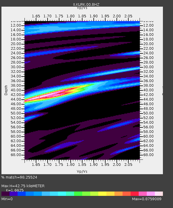
KURK Kurchatov, Kazakhstan - Earthquake Result Viewer

Earthquake location: Bonin Islands, Japan Region
Earthquake latitude/longitude: 26.9/143.7
Earthquake time(UTC): 2010/12/21 (355) 17:19:40 GMT
Earthquake Depth: 14 km
Earthquake Magnitude: 7.4 MW, 7.0 MB, 7.4 MW, 7.5 MS
Earthquake Catalog/Contributor: NEIC PDE/NEIC PDE-M
Network: II Global Seismograph Network (GSN - IRIS/IDA)
Station: KURK Kurchatov, Kazakhstan
Lat/Lon: 50.72 N/78.62 E
Elevation: 184 m
Distance: 54.1 deg
Az: 314.612 deg
Baz: 90.31 deg
Ray Param: 0.06566041
Estimated Moho Depth: 42.75 km
Estimated Crust Vp/Vs: 1.66
Assumed Crust Vp: 6.552 km/s
Estimated Crust Vs: 3.941 km/s
Estimated Crust Poisson's Ratio: 0.22
Radial Match: 98.25524 %
Radial Bump: 312
Transverse Match: 90.341896 %
Transverse Bump: 400
SOD ConfigId: 617450
Insert Time: 2013-10-01 15:53:29.683 +0000
GWidth: 2.5
Max Bumps: 400
Tol: 0.001

Signal To Noise

ChannelStoNSTALTA
II:KURK:00:BHZ:20101221T17:28:33.772976Z104.6438141.5176486E-51.4502994E-7
II:KURK:00:BH1:20101221T17:28:33.772976Z4.62424665.0178306E-71.0851131E-7
II:KURK:00:BH2:20101221T17:28:33.772976Z64.522297.31876E-61.1342994E-7
Arrivals
Ps4.6 SECOND
PpPs16 SECOND
PsPs/PpSs21 SECOND