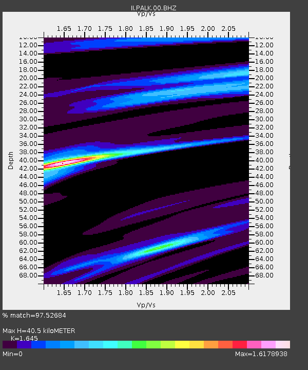
PALK Pallekele, Sri Lanka - Earthquake Result Viewer
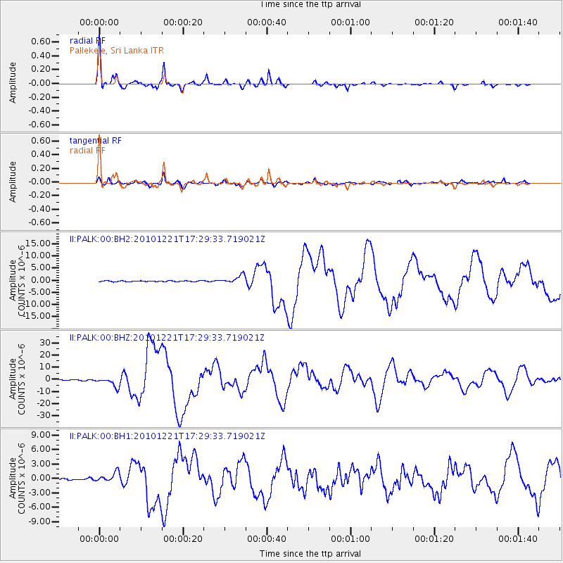
Earthquake location: Bonin Islands, Japan Region
Earthquake latitude/longitude: 26.9/143.7
Earthquake time(UTC): 2010/12/21 (355) 17:19:40 GMT
Earthquake Depth: 14 km
Earthquake Magnitude: 7.4 MW, 7.0 MB, 7.4 MW, 7.5 MS
Earthquake Catalog/Contributor: NEIC PDE/NEIC PDE-M
Network: II Global Seismograph Network (GSN - IRIS/IDA)
Station: PALK Pallekele, Sri Lanka
Lat/Lon: 7.27 N/80.70 E
Elevation: 460 m
Distance: 62.7 deg
Az: 264.159 deg
Baz: 63.571 deg
Ray Param: 0.060054712
Estimated Moho Depth: 40.5 km
Estimated Crust Vp/Vs: 1.64
Assumed Crust Vp: 6.545 km/s
Estimated Crust Vs: 3.979 km/s
Estimated Crust Poisson's Ratio: 0.21
Radial Match: 97.52684 %
Radial Bump: 345
Transverse Match: 90.99106 %
Transverse Bump: 400
SOD ConfigId: 617450
Insert Time: 2013-10-01 15:53:38.762 +0000
GWidth: 2.5
Max Bumps: 400
Tol: 0.001

Signal To Noise

ChannelStoNSTALTA
II:PALK:00:BHZ:20101221T17:29:33.719021Z12.8631034.0358423E-63.1375342E-7
II:PALK:00:BH1:20101221T17:29:33.719021Z5.8575051.0373175E-61.7709203E-7
II:PALK:00:BH2:20101221T17:29:33.719021Z9.9255961.7099593E-61.7227774E-7
Arrivals
Ps4.2 SECOND
PpPs16 SECOND
PsPs/PpSs20 SECOND