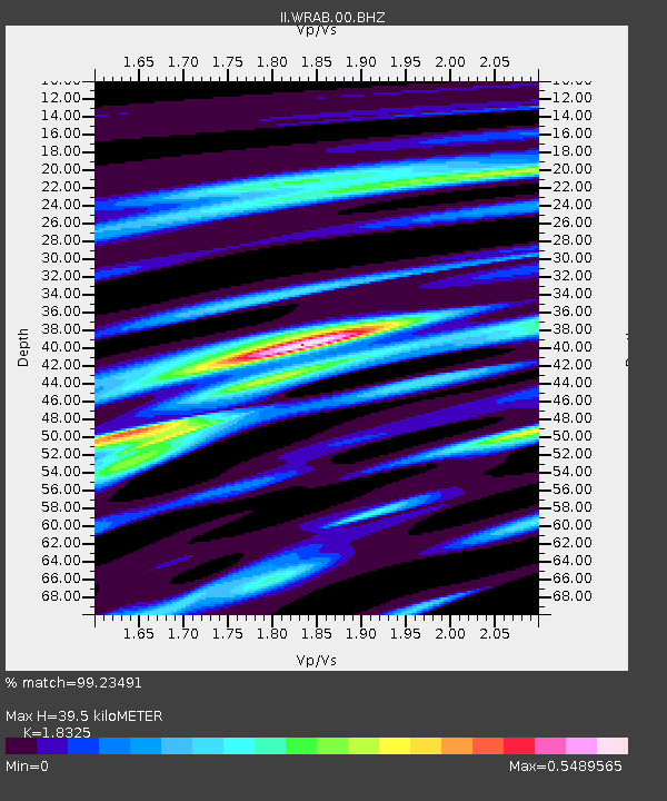
WRAB Tennant Creek, NT, Australia - Earthquake Result Viewer
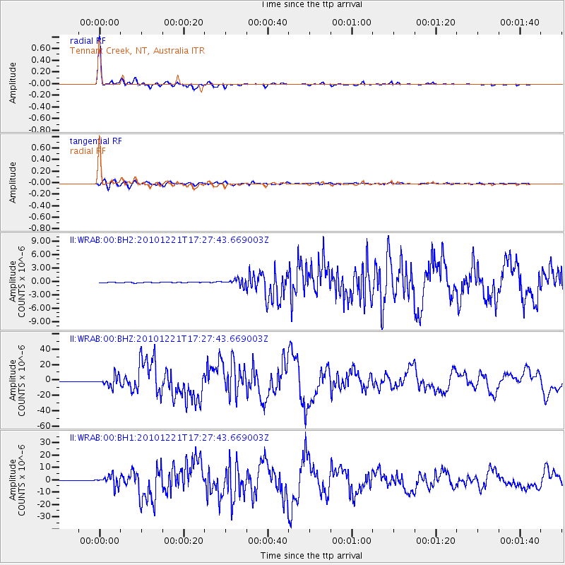
Earthquake location: Bonin Islands, Japan Region
Earthquake latitude/longitude: 26.9/143.7
Earthquake time(UTC): 2010/12/21 (355) 17:19:40 GMT
Earthquake Depth: 14 km
Earthquake Magnitude: 7.4 MW, 7.0 MB, 7.4 MW, 7.5 MS
Earthquake Catalog/Contributor: NEIC PDE/NEIC PDE-M
Network: II Global Seismograph Network (GSN - IRIS/IDA)
Station: WRAB Tennant Creek, NT, Australia
Lat/Lon: 19.93 S/134.36 E
Elevation: 366 m
Distance: 47.4 deg
Az: 191.964 deg
Baz: 11.347 deg
Ray Param: 0.069985144
Estimated Moho Depth: 39.5 km
Estimated Crust Vp/Vs: 1.83
Assumed Crust Vp: 6.642 km/s
Estimated Crust Vs: 3.625 km/s
Estimated Crust Poisson's Ratio: 0.29
Radial Match: 99.23491 %
Radial Bump: 207
Transverse Match: 95.742386 %
Transverse Bump: 400
SOD ConfigId: 617450
Insert Time: 2013-10-01 15:53:46.617 +0000
GWidth: 2.5
Max Bumps: 400
Tol: 0.001

Signal To Noise

ChannelStoNSTALTA
II:WRAB:00:BHZ:20101221T17:27:43.669003Z35.251686.795055E-61.9275834E-7
II:WRAB:00:BH1:20101221T17:27:43.669003Z27.6452164.3670234E-61.579667E-7
II:WRAB:00:BH2:20101221T17:27:43.669003Z8.4214437.3181644E-78.689917E-8
Arrivals
Ps5.3 SECOND
PpPs16 SECOND
PsPs/PpSs21 SECOND