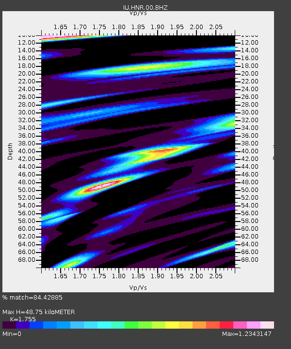
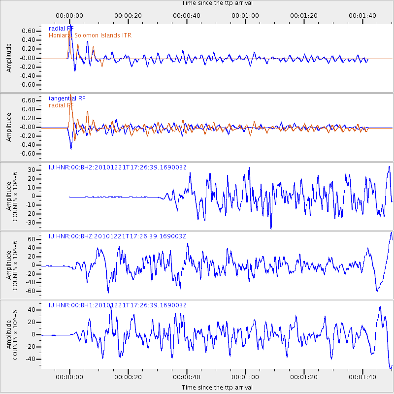
HNR Honiara, Solomon Islands - Earthquake Result Viewer

Earthquake location: Bonin Islands, Japan Region
Earthquake latitude/longitude: 26.9/143.7
Earthquake time(UTC): 2010/12/21 (355) 17:19:40 GMT
Earthquake Depth: 14 km
Earthquake Magnitude: 7.4 MW, 7.0 MB, 7.4 MW, 7.5 MS
Earthquake Catalog/Contributor: NEIC PDE/NEIC PDE-M
Network: IU Global Seismograph Network (GSN - IRIS/USGS)
Station: HNR Honiara, Solomon Islands
Lat/Lon: 9.44 S/159.95 E
Elevation: 100 m
Distance: 39.4 deg
Az: 154.227 deg
Baz: 336.824 deg
Ray Param: 0.07498707
Estimated Moho Depth: 48.75 km
Estimated Crust Vp/Vs: 1.75
Assumed Crust Vp: 6.183 km/s
Estimated Crust Vs: 3.523 km/s
Estimated Crust Poisson's Ratio: 0.26
Radial Match: 84.42885 %
Radial Bump: 400
Transverse Match: 81.57298 %
Transverse Bump: 400
SOD ConfigId: 617450
Insert Time: 2013-10-01 15:54:00.385 +0000
GWidth: 2.5
Max Bumps: 400
Tol: 0.001

Signal To Noise

ChannelStoNSTALTA
IU:HNR:00:BHZ:20101221T17:26:39.169003Z24.6080445.357214E-62.1770175E-7
IU:HNR:00:BH1:20101221T17:26:39.169003Z22.2358264.096373E-61.84224E-7
IU:HNR:00:BH2:20101221T17:26:39.169003Z12.2445432.0186203E-61.6485878E-7
Arrivals
Ps6.4 SECOND
PpPs20 SECOND
PsPs/PpSs27 SECOND