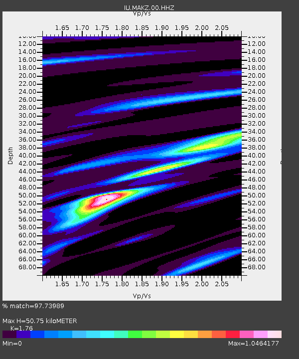
MAKZ Makanchi, Kazakhstan - Earthquake Result Viewer

Earthquake location: Bonin Islands, Japan Region
Earthquake latitude/longitude: 26.9/143.7
Earthquake time(UTC): 2010/12/21 (355) 17:19:40 GMT
Earthquake Depth: 14 km
Earthquake Magnitude: 7.4 MW, 7.0 MB, 7.4 MW, 7.5 MS
Earthquake Catalog/Contributor: NEIC PDE/NEIC PDE-M
Network: IU Global Seismograph Network (GSN - IRIS/USGS)
Station: MAKZ Makanchi, Kazakhstan
Lat/Lon: 46.81 N/81.98 E
Elevation: 600 m
Distance: 51.9 deg
Az: 309.72 deg
Baz: 89.88 deg
Ray Param: 0.06713028
Estimated Moho Depth: 50.75 km
Estimated Crust Vp/Vs: 1.76
Assumed Crust Vp: 6.571 km/s
Estimated Crust Vs: 3.733 km/s
Estimated Crust Poisson's Ratio: 0.26
Radial Match: 97.73989 %
Radial Bump: 313
Transverse Match: 90.64899 %
Transverse Bump: 400
SOD ConfigId: 617450
Insert Time: 2013-10-01 15:54:05.931 +0000
GWidth: 2.5
Max Bumps: 400
Tol: 0.001

Signal To Noise

ChannelStoNSTALTA
IU:MAKZ:00:HHZ:20101221T17:28:17.31802Z92.991471.1718078E-51.260124E-7
IU:MAKZ:00:HH1:20101221T17:28:17.31802Z14.9653035.125226E-73.4247392E-8
IU:MAKZ:00:HH2:20101221T17:28:17.31802Z51.9597935.698797E-61.0967705E-7
Arrivals
Ps6.2 SECOND
PpPs20 SECOND
PsPs/PpSs26 SECOND