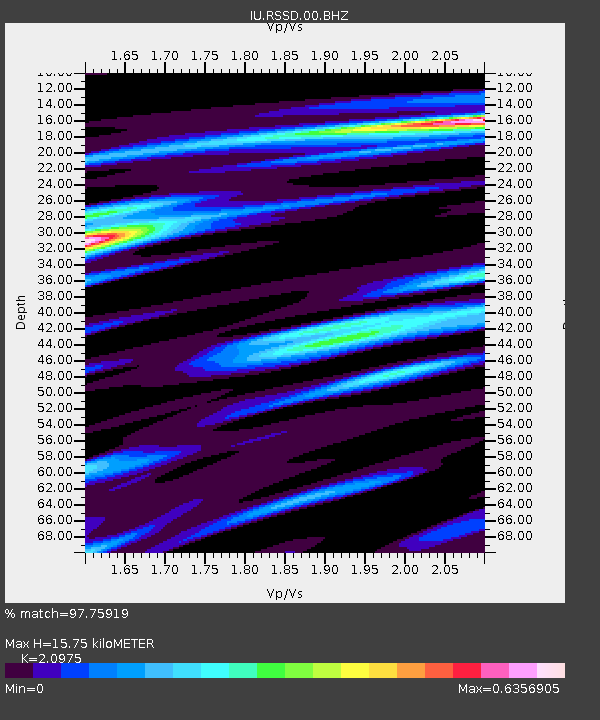
RSSD Black Hills, South Dakota, USA - Earthquake Result Viewer
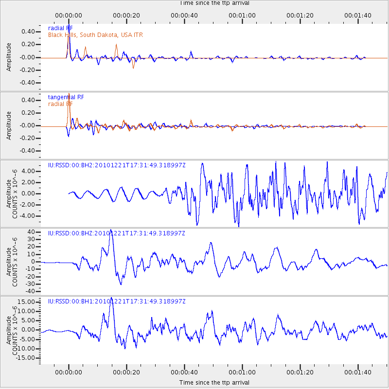
Earthquake location: Bonin Islands, Japan Region
Earthquake latitude/longitude: 26.9/143.7
Earthquake time(UTC): 2010/12/21 (355) 17:19:40 GMT
Earthquake Depth: 14 km
Earthquake Magnitude: 7.4 MW, 7.0 MB, 7.4 MW, 7.5 MS
Earthquake Catalog/Contributor: NEIC PDE/NEIC PDE-M
Network: IU Global Seismograph Network (GSN - IRIS/USGS)
Station: RSSD Black Hills, South Dakota, USA
Lat/Lon: 44.12 N/104.04 W
Elevation: 2090 m
Distance: 86.1 deg
Az: 41.918 deg
Baz: 304.068 deg
Ray Param: 0.044305798
Estimated Moho Depth: 15.75 km
Estimated Crust Vp/Vs: 2.10
Assumed Crust Vp: 6.242 km/s
Estimated Crust Vs: 2.976 km/s
Estimated Crust Poisson's Ratio: 0.35
Radial Match: 97.75919 %
Radial Bump: 287
Transverse Match: 91.04316 %
Transverse Bump: 400
SOD ConfigId: 617450
Insert Time: 2013-10-01 15:54:12.208 +0000
GWidth: 2.5
Max Bumps: 400
Tol: 0.001

Signal To Noise

ChannelStoNSTALTA
IU:RSSD:00:BHZ:20101221T17:31:49.318997Z10.9387614.0866657E-63.7359496E-7
IU:RSSD:00:BH1:20101221T17:31:49.318997Z6.1467341.5584477E-62.5354075E-7
IU:RSSD:00:BH2:20101221T17:31:49.318997Z0.8080095.331696E-76.5985597E-7
Arrivals
Ps2.8 SECOND
PpPs7.7 SECOND
PsPs/PpSs10 SECOND