You are here: Home > Network List > US - United States National Seismic Network Stations List
> Station ECSD EROS Data Center, Sioux Falls, South Dakota, USA > Earthquake Result Viewer
ECSD EROS Data Center, Sioux Falls, South Dakota, USA - Earthquake Result Viewer
| Earthquake location: |
Bonin Islands, Japan Region |
| Earthquake latitude/longitude: |
26.9/143.7 |
| Earthquake time(UTC): |
2010/12/21 (355) 17:19:40 GMT |
| Earthquake Depth: |
14 km |
| Earthquake Magnitude: |
7.4 MW, 7.0 MB, 7.4 MW, 7.5 MS |
| Earthquake Catalog/Contributor: |
NEIC PDE/NEIC PDE-M |
|
| Network: |
US United States National Seismic Network |
| Station: |
ECSD EROS Data Center, Sioux Falls, South Dakota, USA |
| Lat/Lon: |
43.73 N/96.60 W |
| Elevation: |
469 m |
|
| Distance: |
90.6 deg |
| Az: |
39.029 deg |
| Baz: |
309.129 deg |
| Ray Param: |
0.04166 |
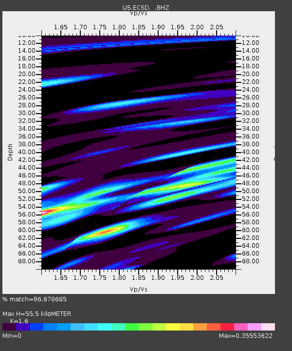
| Estimated Moho Depth: |
55.5 km |
| Estimated Crust Vp/Vs: |
1.60 |
| Assumed Crust Vp: |
6.498 km/s |
| Estimated Crust Vs: |
4.061 km/s |
| Estimated Crust Poisson's Ratio: |
0.18 |
|
| Radial Match: |
96.678665 % |
| Radial Bump: |
324 |
| Transverse Match: |
87.585526 % |
| Transverse Bump: |
400 |
| SOD ConfigId: |
617450 |
| Insert Time: |
2013-10-01 15:54:35.853 +0000 |
| GWidth: |
2.5 |
| Max Bumps: |
400 |
| Tol: |
0.001 |
|
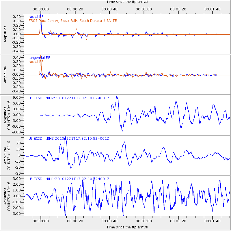
Signal To Noise
| Channel | StoN | STA | LTA |
| US:ECSD: :BHZ:20101221T17:32:10.824001Z | 10.087417 | 4.1953235E-6 | 4.158967E-7 |
| US:ECSD: :BH1:20101221T17:32:10.824001Z | 1.8980603 | 5.4634904E-7 | 2.8784598E-7 |
| US:ECSD: :BH2:20101221T17:32:10.824001Z | 3.4238899 | 1.1787085E-6 | 3.442601E-7 |
| Arrivals |
| Ps | 5.2 SECOND |
| PpPs | 22 SECOND |
| PsPs/PpSs | 27 SECOND |


