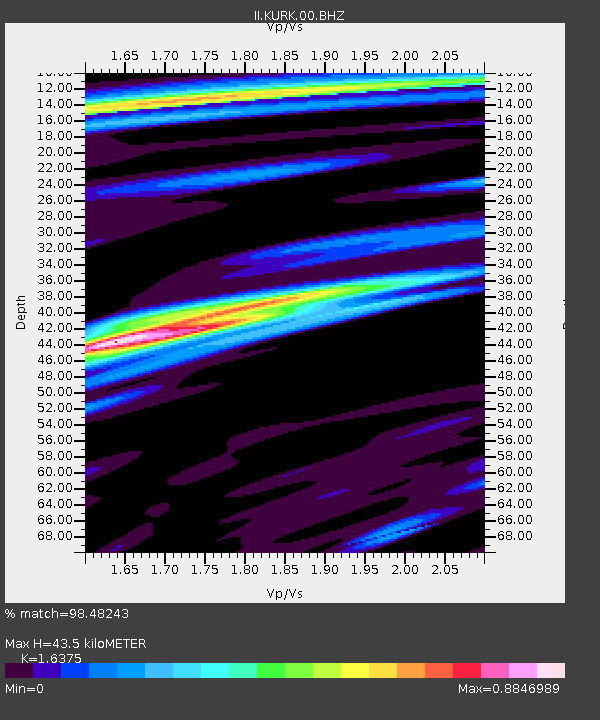
KURK Kurchatov, Kazakhstan - Earthquake Result Viewer
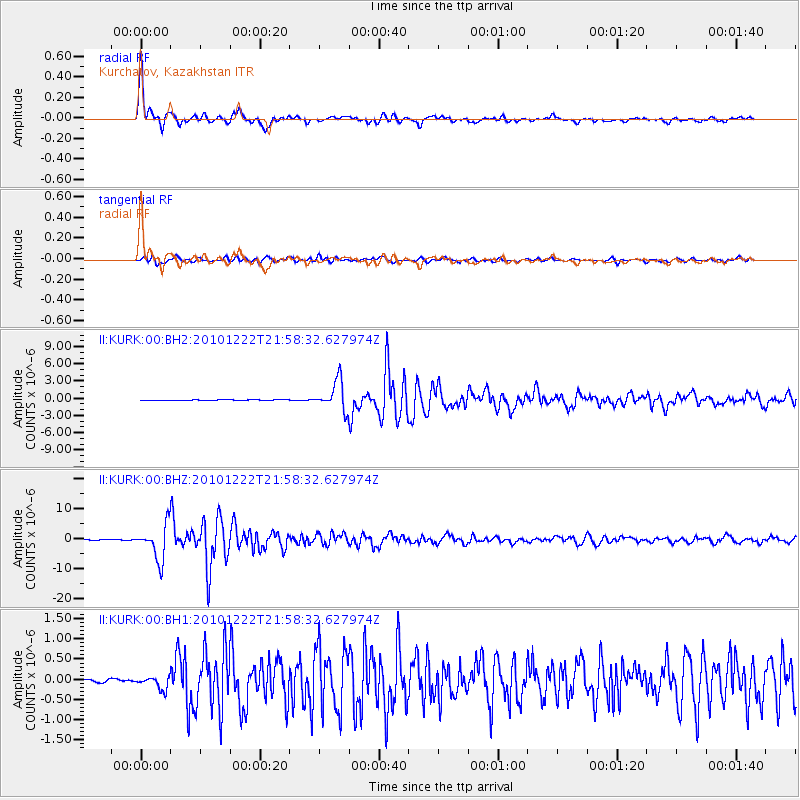
Earthquake location: Bonin Islands, Japan Region
Earthquake latitude/longitude: 26.8/143.6
Earthquake time(UTC): 2010/12/22 (356) 21:49:40 GMT
Earthquake Depth: 18 km
Earthquake Magnitude: 6.4 MW, 6.2 MB, 6.2 MW, 6.3 MS
Earthquake Catalog/Contributor: NEIC PDE/NEIC PDE-M
Network: II Global Seismograph Network (GSN - IRIS/IDA)
Station: KURK Kurchatov, Kazakhstan
Lat/Lon: 50.72 N/78.62 E
Elevation: 184 m
Distance: 54.1 deg
Az: 314.66 deg
Baz: 90.469 deg
Ray Param: 0.06565224
Estimated Moho Depth: 43.5 km
Estimated Crust Vp/Vs: 1.64
Assumed Crust Vp: 6.552 km/s
Estimated Crust Vs: 4.001 km/s
Estimated Crust Poisson's Ratio: 0.20
Radial Match: 98.48243 %
Radial Bump: 356
Transverse Match: 93.3552 %
Transverse Bump: 400
SOD ConfigId: 617450
Insert Time: 2013-10-01 16:01:54.618 +0000
GWidth: 2.5
Max Bumps: 400
Tol: 0.001

Signal To Noise

ChannelStoNSTALTA
II:KURK:00:BHZ:20101222T21:58:32.627974Z81.089255.8358582E-67.196834E-8
II:KURK:00:BH1:20101222T21:58:32.627974Z4.07543951.5208961E-73.731858E-8
II:KURK:00:BH2:20101222T21:58:32.627974Z51.7202452.5519948E-64.9342283E-8
Arrivals
Ps4.5 SECOND
PpPs16 SECOND
PsPs/PpSs21 SECOND