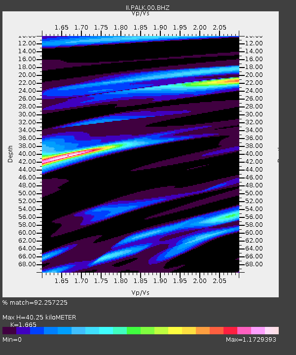
PALK Pallekele, Sri Lanka - Earthquake Result Viewer
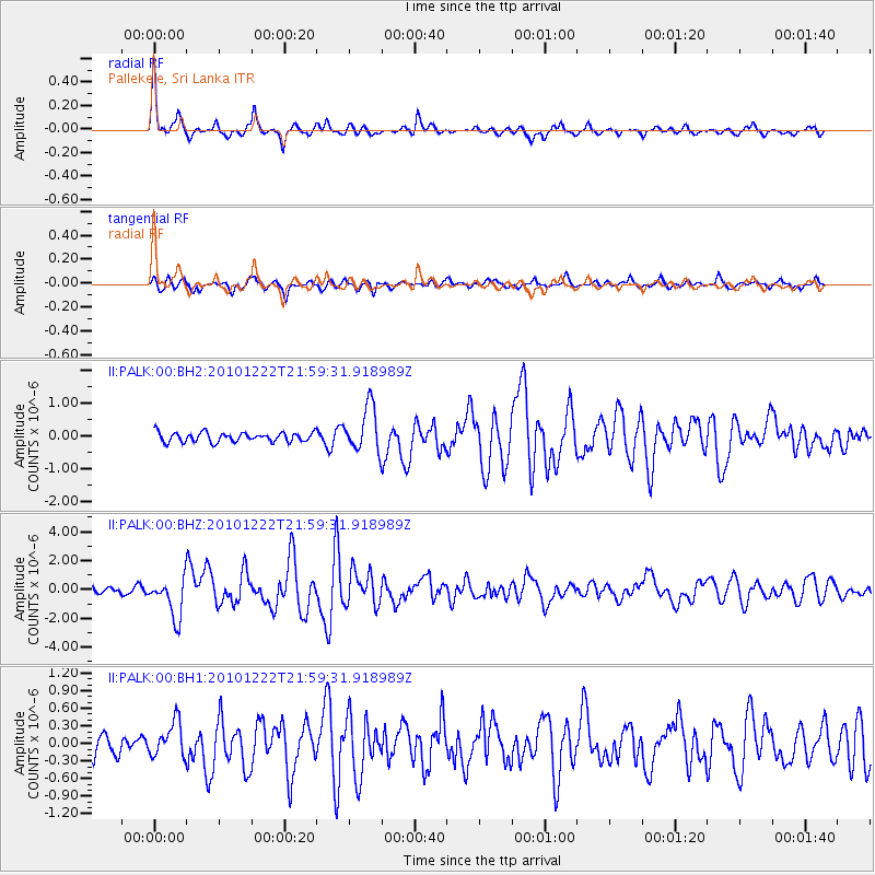
Earthquake location: Bonin Islands, Japan Region
Earthquake latitude/longitude: 26.8/143.6
Earthquake time(UTC): 2010/12/22 (356) 21:49:40 GMT
Earthquake Depth: 18 km
Earthquake Magnitude: 6.4 MW, 6.2 MB, 6.2 MW, 6.3 MS
Earthquake Catalog/Contributor: NEIC PDE/NEIC PDE-M
Network: II Global Seismograph Network (GSN - IRIS/IDA)
Station: PALK Pallekele, Sri Lanka
Lat/Lon: 7.27 N/80.70 E
Elevation: 460 m
Distance: 62.6 deg
Az: 264.155 deg
Baz: 63.662 deg
Ray Param: 0.060111236
Estimated Moho Depth: 40.25 km
Estimated Crust Vp/Vs: 1.66
Assumed Crust Vp: 6.545 km/s
Estimated Crust Vs: 3.931 km/s
Estimated Crust Poisson's Ratio: 0.22
Radial Match: 92.257225 %
Radial Bump: 381
Transverse Match: 85.0808 %
Transverse Bump: 400
SOD ConfigId: 617450
Insert Time: 2013-10-01 16:02:02.696 +0000
GWidth: 2.5
Max Bumps: 400
Tol: 0.001

Signal To Noise

ChannelStoNSTALTA
II:PALK:00:BHZ:20101222T21:59:31.918989Z7.7699251.385884E-61.7836517E-7
II:PALK:00:BH1:20101222T21:59:31.918989Z1.71139972.990453E-71.7473727E-7
II:PALK:00:BH2:20101222T21:59:31.918989Z4.8312446.924749E-71.4333263E-7
Arrivals
Ps4.3 SECOND
PpPs16 SECOND
PsPs/PpSs20 SECOND